FORECAST HIGHLIGHTS
- TEENS & 20S THIS AM: Cold enough for a record low in SA
- FEW SLICK SPOTS: Can’t rule out a few remaining slick spots on roads
- ABOVE FREEZING LATER TODAY: Temps to reach the upper-30s
FORECAST
BITTER COLD START
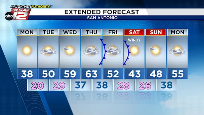
Temperatures have slipped into the low-20s and teens around San Antonio. We’ve already tied a record low and may very well set the record low for the date (20°, 1897). While most well-driven roads have dried out, there still could be a few slick spots around town. Once the sun rises (7:26am), any remaining ice should melt. Around midday, temperatures are forecast to rise above 32°. At that point, San Antonio will have spent more than 40 hours below freezing. Sunshine will push temps into the upper-30s this afternoon.

COLD AGAIN TONIGHT
Tonight, temperatures will crater under clear skies. A low of 20° is forecast in San Antonio, once again nearing a record.

MORE COLD FRONTS LATER THIS WEEK
While we will see a warm-up over the next few days, another front is poised to slide through on Friday. This will be followed by a reinforcing shot of cold air on Saturday. This go-round, we do not expect precipitation with these systems. However, more freezes lie ahead by the weekend.

QUICK WEATHER LINKS
- WATCH LIVE: Doppler Radar
- Hourly and 10-Day Forecast
- Download FREE KSAT Weather Authority App: Up-to-date forecast information and livestreams from trusted local meteorologists.
- KSAT Connect: Share your weather photos.