FORECAST HIGHLIGHTS
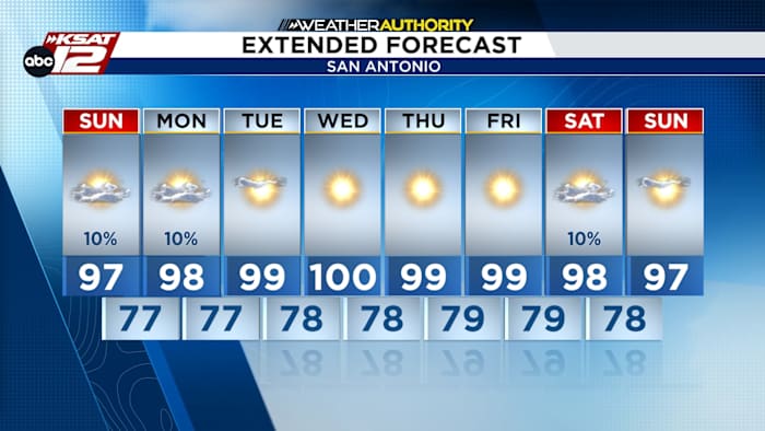
- SUNDAY: Small rain chances, highs near 100.
- BACK TO SCHOOL: Hot and humid with a few isolated showers.
- HEATING UP: Many areas reaching 100-102 degrees and potentially higher heat indices.
FORECAST
TODAY
High pressure will keep skies sunny and temperatures in the mid-90s to near 100 on Sunday. High humidity will push heat indices to 108 degrees, especially near the Coastal Plains. While most of South-Central Texas remains dry, a 15-20% chance of isolated afternoon showers exists east of I-35.

BACK-TO-SCHOOL: HOT AND HUMID
The first day back to school will bring more heat and humidity. Monday’s forecast looks very similar to Sunday, with afternoon highs again reaching the mid to upper 90s and possibly near 100 degrees. A few isolated sea-breeze showers could develop during the afternoon, mainly closer to the Coastal Plains, but most of the region should remain dry.

For students, parents, teachers and anyone spending time outside Monday, the bigger concern will be the heat. Plan for a hot afternoon, stay hydrated and take breaks from the heat when possible.
EXTENDED OUTLOOK
As the upper-level ridge shifts southeast this week, rain chances fade by Tuesday and temperatures climb to near triple digits. High humidity could push heat indices to 108+ degrees. While humidity may dip next weekend, the region will remain unseasonably hot.

QUICK WEATHER LINKS
- WATCH LIVE: Doppler Radar
- Hourly and 10-Day Forecast
- Download FREE KSAT Weather Authority App: Up-to-date forecast information and livestreams from trusted local meteorologists.
- KSAT Connect: Share your weather photos.