FORECAST HIGHLIGHTS
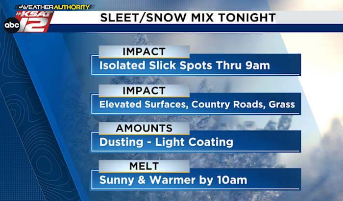
- WINTRY MIX: Light glaze and mix of sleet/ice pellets and snow, lasting through sunrise Tuesday
- MINOR IMPACTS: Slick spots mainly on bridges and overpasses and less travelled roads
- ACCUMULATION: Dusting/light coating of ice pellets and snow on grass, dirt, country roads, decks, parked vehicles etc.
- MELTING: Sunshine returns by 10am Tuesday causing a quick melt
- HARD FREEZE WEDNESDAY MORNING: Lows near 20°
FORECAST
TONIGHT
A light glaze is forming on some elevated surfaces such as street signs, parked vehicles, decks, etc. and will mix with sleet and snowflakes through the night. But you won’t be able to make a snowman or even make much of a snowball in the morning because accumulations will be minimal (less than 1″). Precipitation will peak between midnight and 5am Tuesday, then the sun comes out by 10am causing a rapid melting.
*NOTE: Contrary to conventional thinking, conditions will actually be better across the Hill Country this go around. The higher moisture availability which could lead to slightly higher accumulations will be positioned between I-10 and I-37.
- Accumulation of any snow and sleet will be less than an inch
- Glaze ice accumulations will be LIGHT and on elevated surfaces- less than .10″
- Still, even a small amount of ice can make for slick spots, mainly on bridges and overpasses
TUESDAY MORNING
Light snow and sleet will come to an end by sunrise tomorrow. However, watch for slicks spots on some of the bridges and overpasses and even less-traveled roads until about 10am. Accumulations of sleet (ice pellets) and snow should be less than an inch and mostly just a dusting/light coating on the grass, dirt, gravel driveways, decks, parked vehicles, etc. Again, sunshine will take over around 10am and cause a rapid melt.
Sunshine will allow temperatures to reach 40° in the afternoon, but then a hard freeze is upon us Tuesday night/Wednesday morning with lows near 20°, which is the coldest yet this winter.

REST OF THE WEEK
Morning freezes are expected through Friday, but afternoons will get warmer with highs in the 50s by Thursday and Friday, then into the 60s over the weekend.

QUICK WEATHER LINKS
- WATCH LIVE: Doppler Radar
- Hourly and 10-Day Forecast
- Download FREE KSAT Weather Authority App: Up-to-date forecast information and livestreams from trusted local meteorologists.
- KSAT Connect: Share your weather photos.