FORECAST HIGHLIGHTS
- SUNDAY: Morning mist, cloudier, still near 90°. Gusts up to 25-30 mph.
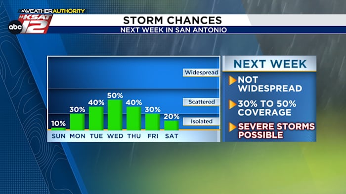
- NEXT WEEK: 30% to 40% daily storm chances, some strong
FORECAST
TOMORROW
Sunday starts off with patchy mist in a few spots, especially early in the morning. Clouds will stick around longer during the day, but we should still see some sunshine by the afternoon. Highs will again be near 90°, but it will feel hotter thanks to the humidity.

There’s also a small chance for an isolated shower or storm late in the day, mainly east of I-35. Not everyone will see rain, but any storm that forms could bring gusty winds and a quick heavy downpour.
NEXT WEEK
Our weather pattern next week will be unsettled. Rounds of energy and a slow-moving cool front will keep storms in the forecast daily. It won’t be a washout each day. Rather, chances AND coverage stand at 30% to 0%.

Again, timing and placement of any storm is impossible to know at this point, but wherever storms set up, we’ll have the ingredients for strong or severe storms. Beyond that, low rain chances stay with us, potentially through Memorial Day weekend.

QUICK WEATHER LINKS
- WATCH LIVE: Doppler Radar
- Hourly and 10-Day Forecast
- Download FREE KSAT Weather Authority App: Up-to-date forecast information and livestreams from trusted local meteorologists.
- KSAT Connect: Share your weather photos.