FORECAST HIGHLIGHTS
- RIVER FLOODING: Major to moderate flooding still underway, high water moving downstream
- DRIER FORECAST: Quieter conditions take over this weekend for all
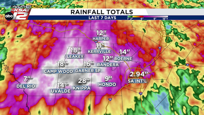
- UPDATED RAINFALL TOTALS: Historic rainfall totals over the last week
- AQUIFER/LAKE UPDATES: Aquifer and area lakes still rising
FORECAST
EVENING UPDATE
Water-logged areas can take a small sigh of relief, as heavy rain has ended for most of us. Flash flooding no longer expected for the area, except around rivers. Rain is not expected tonight, nor in the week ahead.
Don’t forget, most of our major rivers are now transporting massive amounts of water downstream — either toward the Gulf or into area lakes. If you live near a river or creek, pay very close attention to your surroundings!
AREAS THAT MAY STILL SEE HIGH WATER ALONG AREA RIVERS:
Eagle Pass — Rio Grande
Crystal City, Asherton, Cotulla — Nueces River
Derby, Fowlerton, Choke Canyon — Frio River
Stockdale, Falls City, Kenedy — Cibolo Creek and San Antonio River

UPDATED RAINFALL TOTALS AS OF FRIDAY:

AQUIFER/LAKE UPDATES:
The aquifer continues to rise, while Medina and Canyon Lake will continue to see water feed into the reservoirs via swollen rivers and creeks. Here are the latest numbers:

QUICK WEATHER LINKS
- WATCH LIVE: Doppler Radar
- Hourly and 10-Day Forecast
- Download FREE KSAT Weather Authority App: Up-to-date forecast information and livestreams from trusted local meteorologists.
- KSAT Connect: Share your weather photos.