NWS: Cold front, thunderstorms expected for the weekend
-
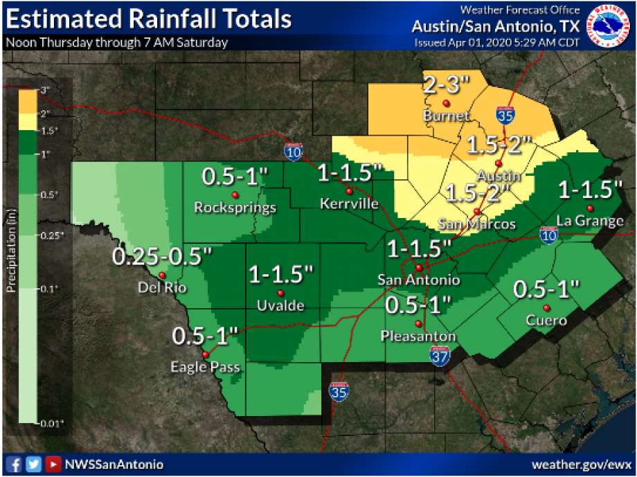
South and Central Texas could see rainfall and storms Friday night into Saturday morning from an approaching cold front, according to the National Weather Service. San Antonio could see 1 to 2 inches of rain, with up to 4 inches possible.
South and Central Texas could see rainfall and storms Friday night into Saturday morning from an approaching cold front, according to the National Weather Service. San Antonio could see 1 to 2 inches of rain,
Photo: National Weather Service
This recent enjoyable weather in the region that has been perfect for walking is expected to be interrupted this weekend.
South and Central Texas could see rainfall and storms Friday night into Saturday morning from an approaching cold front, according to the National Weather Service. San Antonio could see 1 to 2 inches of rain, with up to 4 inches possible.
The strongest storms will likely follow the front as it moves into the area, which is expected Friday night.
GOOD NEWS: Because we need more of it, submit your story and we may feature it in an upcoming article
Large hail up to 2 inches in diameter as well as damaging winds are possible during the storms, the NWS said. The potential for flooding and tornadoes are both possible during the storms.
The rainfall and storms should clear by late Saturday morning, but precipitation is possible throughout the rest of the weekend.
Taylor Pettaway is a breaking news reporter and general assignment writer. Read her on our breaking news site, MySA.com, and on our subscriber site, ExpressNews.com | [email protected] | @TaylorPettaway