WATCH LIVE RADAR ABOVE
FORECAST HIGHLIGHTS
- TODAY: Mostly cloudy and cooler, small chance of a shower
- FRIDAY EVENING/NIGHT: Best chance for storms, severe weather possible
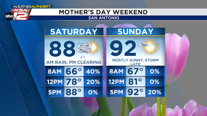
- SATURDAY: Rain early, then afternoon clearing
- MOTHER’S DAY: Mostly sunny and HOT, small shot at storms by evening
FORECAST
TODAY
Yesterday’s cold front has brought in lower humidity and noticeably cooler temperatures. Expect mostly cloudy skies through the day, which will keep highs well below average—in the 60s to low 70s. A stray shower is possible, but most locations stay dry with rain chances around 20%.

RAIN CHANCES FRIDAY, EARLY SATURDAY
An upper-level low will help generate storms late Friday afternoon. Storms will initially develop near the Rio Grande and then push east toward San Antonio Friday evening and overnight Friday.

While widespread severe weather is not anticipated, strong storms are possible. The main concern with this system will be locally heavy rainfall, especially Friday night into early Saturday. This activity will continue into early Saturday morning, before moving east of the area by midday. Expect clearing skies, with lower humidity Saturday afternoon.
MOTHER’S DAY

We’ll see plenty of sunshine on Sunday, which will send temperatures soaring. Low-90s are in the forecast by the afternoon. Most of the day will be quiet, however, a front is forecast to arrive by the evening. An isolated storm may develop late in the day or during the evening hours. Rain chances remain low at around 20%.

QUICK WEATHER LINKS
- WATCH LIVE: Doppler Radar
- Hourly and 10-Day Forecast
- Download FREE KSAT Weather Authority App: Up-to-date forecast information and livestreams from trusted local meteorologists.
- KSAT Connect: Share your weather photos.