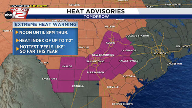
FORECAST HIGHLIGHTS:
- Spotty showers found earlier in the day will continue to wind down Saturday night
- Just an isolated chance for rain Sunday, then even drier early next week
- Saharan dust is moving through this weekend, no major impacts to air quality expected
FORECAST:
After finding more spotty downpours and non-severe storms Saturday, just an isolated (20%) chance for rain is in the forecast on Sunday with highs in the mid-90s by the afternoon. Morning cloud cover should lead to a bit more sunshine after lunch with winds generally out of the south at 5 to 10 mph.

A drier trend takes over by Monday and Tuesday with partly cloudy skies and mid-90s still the theme.
A weak front will approach from the north by the second half of the week, potentially sparking up slightly better chances for rain and keeping highs contained to the mid-90s ahead of next weekend.
SAHARAN DUST:
A plume of Saharan dust will continue to pass through the South Central Texas sky this weekend. You’ll notice a slightly hazier sky, especially during sunrises and sunsets. Air quality is expected to be okay.
More updates to come in the days ahead! Until then, have a great evening. ~ Mia