FORECAST HIGHLIGHTS
- WEDNESDAY: Warm with spotty afternoon storms (40%)
- THURSDAY & THURSDAY NIGHT: Highest chance for rain (90%)
-
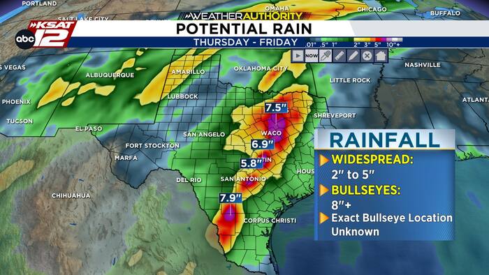
- RAINFALL: 2-5″ possible, however, isolated spots could see 8+”
-
- RISKS: Street, creek, river flooding
- FRIDAY & WEEKEND: Lingering rain at times, but it will be lighter in nature
FORECAST

FLOOD WATCH
An upper level low, the remnants of Hurricane Polo, and a slow-moving cool front will bring beneficial rain to Texas, but will come with the risk for pockets of flooding.
Many Texans, including San Antonio, are under a Flood Watch until Friday. Remember: A “watch” means the ingredients for flooding are there, and we need to be alert until the Watch is discontinued. If you get a flood “warning” that is more serious, and means that flooding is happening or will begin soon.
Here’s what you need to know:

WEDNESDAY
While there could be some storms nearer to the Rio Grande, San Antonio will be mostly quiet — except for the afternoon hours. Tomorrow afternoon, there will be a few spotty storms (40%). Some could be strong, so we’ll monitor carefully.
THURSDAY & THURSDAY NIGHT
The front will slowly make its way toward San Antonio on Thursday, with storms almost a sure bet by Thursday afternoon. Heavy rainfall and street flooding is a risk. Abundant moisture and training of storms could create isolated rainfall of 8″+ somewhere across South Central Texas. However, most will see beneficial rain totals in the 1-4″ range.
If you happen to get a bullseye of 6″+, street and creek flooding is likely. Be careful on the roads Thursday! We’re on standby to see how the rain impacts after-school activities.
FRIDAY (10/2) — RAIN LIKELY, BUT NOT AS INTENSE
The front should slowly move south and east, pushing the threat for the heaviest rainfall south of San Antonio on Friday. However, showers and a storm or two is still possible during the day on Friday
THIS WEEKEND — LIGHTER RAIN, LOWER CHANCES
Lighter rainfall is expected over the weekend, before chances come to an end early next week. Temperatures will benefit from the rain and give us a decent cool down. Next week, humidity will drop and it will actually feel like fall!

QUICK WEATHER LINKS
- WATCH LIVE: Doppler Radar
- Hourly and 10-Day Forecast
- Download FREE KSAT Weather Authority App: Up-to-date forecast information and livestreams from trusted local meteorologists.
- KSAT Connect: Share your weather photos.