FORECAST HIGHLIGHTS
- AFTERNOON WARMTH: Sunny, above average through Friday
- FRIDAY EVENING FRONT: No set timeline, cooler weekend
- NEXT RAIN CHANCE?: Middle of next week
FORECAST
TODAY
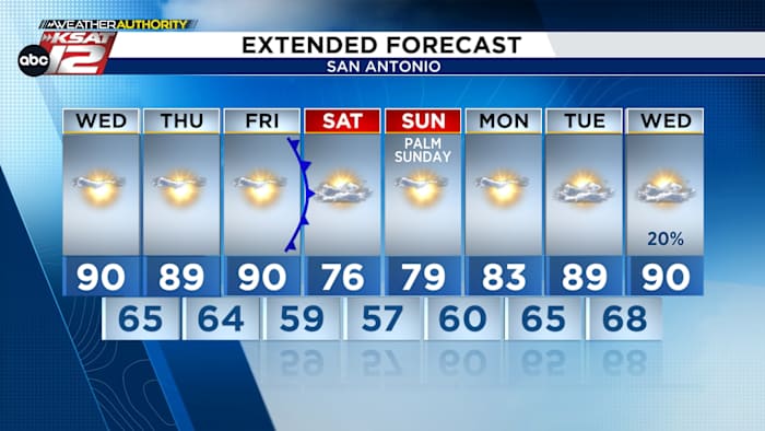
Today, we continue the surge of warm air, with highs well above normal for late March. Temperatures climb into the upper 80s to low 90s as this hot pattern is expected to continue through Friday.

FRONT FRIDAY
Friday brings a similar pattern, then a weak cold front moves through during the evening. While this front will still bring nice changes, new data indicates that the front could bring a small cool down, but not as impactful as once thought. Nonetheless, it should cool things off into the upper 70s with drier weather expected on Saturday through Sunday morning.
NEXT RAIN CHANCE
As of now, a pattern shift should bring rain back into the picture by the middle and end of next week.

QUICK WEATHER LINKS
- WATCH LIVE: Doppler Radar
- Hourly and 10-Day Forecast
- Download FREE KSAT Weather Authority App: Up-to-date forecast information and livestreams from trusted local meteorologists.
- KSAT Connect: Share your weather photos.