FORECAST HIGHLIGHTS
- WEDNESDAY MORNING: Upper-60s expected for San Antonio
- WARM AFTERNOONS: Highs in the 90s
- LAST 100° DAY?: The latest 100° for SA on record is in late September
FORECAST
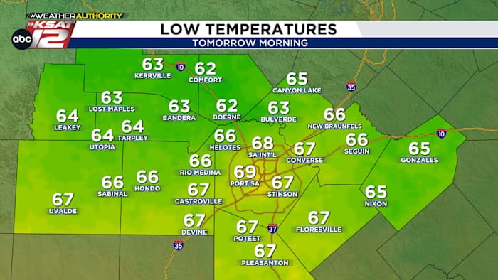
TOMORROW MORNING
With clear skies, temperatures will fall tonight. By sunrise tomorrow, it’ll once again be cooler than average. Morning lows will be in the low-60s in the Hill Country and in the upper-60s around San Antonio…very nice!
REST OF WEEK
Mornings will trend closer to what’s average the rest of the week. We’ll wake up in the low-70s. Afternoons will be toasty, in the mid-90s, but with low afternoon humidity, it really won’t feel all that bad.
No rain in the 7-day forecast.

LAST 100° DAY?
No triple digits are in the forecast, so can we unequivocally say that we’re done with temps above 100°? Unfortunately, no. While the odds of that increase day by day, San Antonio has seen triple digits as late as September 28th. In fact, on September 28, 2005, San Antonio suffered through a high of 104°.

QUICK WEATHER LINKS
- WATCH LIVE: Doppler Radar
- Hourly and 10-Day Forecast
- Download FREE KSAT Weather Authority App: Up-to-date forecast information and livestreams from trusted local meteorologists.
- KSAT Connect: Share your weather photos.