WATCH LIVE RADAR ABOVE
FORECAST HIGHLIGHTS
- TODAY: Morning showers & Storms; cooler in 60s
- MONDAY: Scattered drizzle
- TUESDAY: Stronger & widespread storm chances
- EXTENDED: Quieter, near average
FORECAST
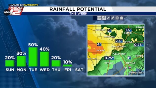
The active pattern continues today and into midweek. The storms we were watching for earlier have continued to weaken, allowing for the hail threat to switch to a flood threat. Radar indicates over 2″ of rain has fallen near New Berlin down to Elmendorf.
The spotty showers & storms are expected to continue through midday, while it turns breezy, humid, and milder.
NEXT RAIN CHANCES
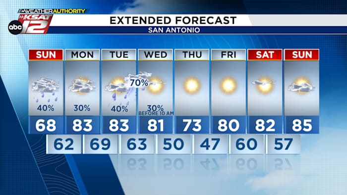
Scattered showers and a few rumbles of thunder linger through Monday as the front washes out and southerly humidity returns. The main system arrives Tuesday, bringing the best chance for organized storms—possibly forming a squall line—between Tuesday afternoon and early Wednesday morning. Strong to marginally severe storms most likely Tuesday afternoon into Wednesday morning. Once that clears, the region dries out completely with temperatures trending much warmer, pushing well into the 80s and approaching 90 by next weekend.

EXTENDED FORECAST
After midweek storms move out, the rest of the week stays dry with temperatures warming into the 80s and near 90 by Saturday.

QUICK WEATHER LINKS
- WATCH LIVE: Doppler Radar
- Hourly and 10-Day Forecast
- Download FREE KSAT Weather Authority App: Up-to-date forecast information and livestreams from trusted local meteorologists.
- KSAT Connect: Share your weather photos.