FORECAST HIGHLIGHTS
- TONIGHT: Scattered showers and storms. Street flooding is the primary threat
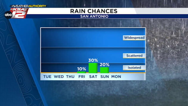
- FRIDAY: 20% chance pop-up afternoon showers
- SATURDAY: Confidence is growing for locally heavy rainfall
FORECAST
TODAY’S RAIN
Quick showers & storms this morning produced healthy rainfall around the area, but we’re not done with rain yet. Plan for more rounds of storms through the next ten days.

REST OF TODAY/TONIGHT
Spotty showers and storms this evening are likely to becoming more numerous overnight, but it should all be done by the morning commute.
FRIDAY AND MEMORIAL DAY WEEKENED
- FRIDAY: After a chance for morning storms, most of Friday is likely to be relatively quiet. Expect partly cloudy skies and warm temperatures.

- SATURDAY: Energy from the west will enhance rain chances yet again on Saturday (60%). A messy upper level setup will make it tough to pinpoint timing and amounts. Clouds and rain will make for slightly cooler temperatures.
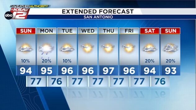
- SUNDAY: Quieter weather is forecast for Sunday, with the sun making a return. Highs will reach the mid-80s
- MONDAY: Only isolated storms are expected (20%). Temperatures will reach to near 90.

QUICK WEATHER LINKS
- WATCH LIVE: Doppler Radar
- Hourly and 10-Day Forecast
- Download FREE KSAT Weather Authority App: Up-to-date forecast information and livestreams from trusted local meteorologists.
- KSAT Connect: Share your weather photos.