FORECAST HIGHLIGHTS
- TODAY: Near 90°, feels like 100°
- WILD CARD: 20% storm chance from 3 pm to 8 pm
-
- SEVERE POTENTIAL: *IF* a rogue storm develops, it would likely produce hail
- THIS WEEK: Hot & humid weather continues, with an isolated storm potential each day
- COLD FRONT FRIDAY: Temp drop by end of the week, higher rain chances Friday
FORECAST
TODAY
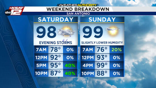
We’ll have some sun and temperatures will climb to near 90°. With high humidity, it’ll feel closer to 100°.
The wildcard today is what we’ve been dealing with the last couple of days: A stray severe storm. A “cap” on the atmosphere should limit storm development. The “cap” acts as a weak lid on the atmosphere. If the “cap” breaks, then a storm producing large hail is likely. The chance of the “cap” breaking from 3 pm to 8 pm is about 20%.

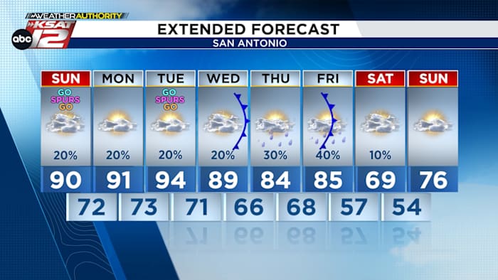
THROUGH WEDNESDAY
Similar weather day-to-day with cloudy mornings and hot, sunnier afternoons. We’ll carry a small chance (20%) for a severe storm each afternoon from 3 pm to 8 pm.
THURSDAY & FRIDAY
A slow-moving cool front will push through South Central Texas. This will drop temps into the 80s with higher rain chances (30%-40%).
WEEKEND
Much cooler! Mornings will be in the 50s with highs only in the 60s & 70s.

QUICK WEATHER LINKS
- WATCH LIVE: Doppler Radar
- Hourly and 10-Day Forecast
- Download FREE KSAT Weather Authority App: Up-to-date forecast information and livestreams from trusted local meteorologists.
- KSAT Connect: Share your weather photos.