FORECAST HIGHLIGHTS
- LABOR DAY WEEKEND
-
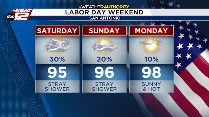
- SATURDAY: 30% rain and storm chance
- SUNDAY: 20% rain and storm chance
- MONDAY: 10% rain and storm chance
- Next week: Hot and humid, with temperatures generally staying below 100 degrees
FORECAST
SATURDAY
As remnants of Tropical Storm Edouard depart, an incoming Gulf disturbance will trigger isolated showers and storms today. Rain chances are highest in the Southern Edwards Plateau, Western Hill Country, and Coastal Plains, while the I-35 corridor remains mostly dry. Rainfall will be light, but locally heavy downpours are possible.

High temperatures will climb into the mid to upper 90s. Despite staying below 100 degrees, high humidity will make it feel hotter, with afternoon heat indices reaching 102 to 107 degrees along and east of I-35 and into parts of the Rio Grande Plains.
LABOR DAY WEEKEND
Sunday brings a chance of isolated storms, mainly across the Coastal Plains and Southern Edwards Plateau, while the I-35 corridor stays mostly dry. Highs will reach the mid-to-upper 90s with high humidity. Rain chances decrease Monday, though isolated coastal storms remain possible. Conditions will stay hot and humid, with highs in the mid-to-upper 90s and muggy overnight lows in the 70s.

EXTENDED OUTLOOK
Expect persistent heat and humidity next week, with highs in the mid-to-upper 90s and elevated heat indices east of I-35. Daily isolated storms are likely near the coast, with a potential increase in rain chances late week as a Gulf disturbance approaches.

QUICK WEATHER LINKS
- WATCH LIVE: Doppler Radar
- Hourly and 10-Day Forecast
- Download FREE KSAT Weather Authority App: Up-to-date forecast information and livestreams from trusted local meteorologists.
- KSAT Connect: Share your weather photos.