Rounds of rain this week have brought multi-inch rainfall totals to parts of South Central Texas, helping the Edwards Aquifer and area rivers, along with improving areas of drought.
Key Points
- Since Sunday (Jan. 21), over 5 and a half inches of rain have fallen in San Antonio
- This rain brings our monthly total to 6.72 inches, marking January 2024 as the second-wettest January on record
- The Edwards Aquifer has risen significantly over the past few days, now up over 8 feet since the start of the week and measuring in at the highest level since June 2023
- While still below average, streamflow has noticeably improved for a few area rivers, namely the Guadalupe and Comal
- Thursday morning’s drought monitor showed some improvements, with more likely on the way next week
Rainfall Totals
Below is a look at rainfall totals across the area since Sunday (Jan. 21). All in all, higher totals were found farther east, and lower totals farther west.
| Location | Rainfall Total |
|---|---|
| San Antonio International Airport | 5.56″ |
| Stinson Municipal Airport | 3.96″ |
| Kelly Field | 3.74″ |
| Randolph Air Force Base | 4.43″ |
| Boerne Stage Field | 1.90″ |
| Helotes | 2.91″ |
| Alamo Ranch | 4.80″ |
| Adkins | 4.27″ |
| Garden Ridge | 6.43″ |
| Schertz | 5.15″ |
| Universal City | 2.95″ |
| Downtown San Antonio | 5.49″ |
| Kerrville | 0.75″ |
| Castroville | 3.77″ |
| Hondo | 0.97″ |
| Floresville | 2.44″ |
| Sutherland Springs | 3.36″ |
| Seguin | 3.60″ |
| Gonzales | 7.14″ |
| Hallettsville | 7.24″ |
| Rocksprings | 0.12″ |
| Del Rio International Airport | 0.14″ |
| Eagle Pass | 0.26″ |
| Pearsall | 3.10″ |
| Cotulla | 0.93″ |
| Bulverde | 4.46″ |
| Canyon Lake | 4.77″ |
| New Braunfels | 3.72″ |
| Kenedy | 4.68″ |
| Rio Medina | 2.27″ |
| Windcrest | 4.04″ |
| St. Hedwig | 5.12″ |
| New Berlin | 4.37″ |
| Shavano Park | 5.94″ |
| Stone Oak | 4.71″ |
| Medical Center | 3.82″ |
| Leon Springs | 3.27″ |
| Elmendorf | 3.22″ |
| Lytle | 4.03″ |
| Devine | 3.80″ |
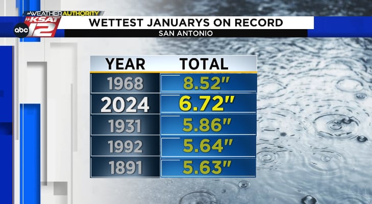
The 5.56 inches recorded at SA International this week brings our official total to 6.72 inches for the month of January.
This makes January 2024 the second wettest January of all time, coming in behind 1968 with 8.52 inches!
For context, rain totals for the year didn’t reach this level until April last year.
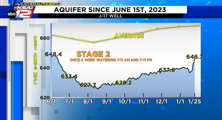
Edwards Aquifer
The J-17 Well of the Edwards Aquifer has risen significantly over the past few days, now up over 8 feet since Sunday.
Thursday’s level of 646.7 feet is the highest level recorded since June of 2023!
We still have a ways to go as the historical monthly average is 668.7 feet, but at least we’ve been trending in the right direction.
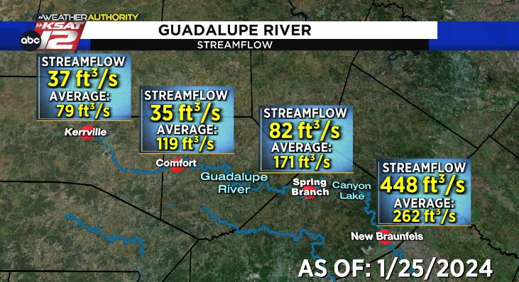
River Streamflow
Thursday morning’s data from the United States Geological Survey (USGS) shows that streamflow of both Guadalupe and Comal Rivers has improved due to these recent rains.
For context, the Guadalupe River at Spring Branch was reporting a streamflow of just 20 cubic feet per second on Sunday (Jan. 21). As of Thursday, Jan. 25, streamflow has risen to 82 cubic feet per second.
We are still below average in many locations and additional fluctuations are likely, but notable improvements this week nonetheless.
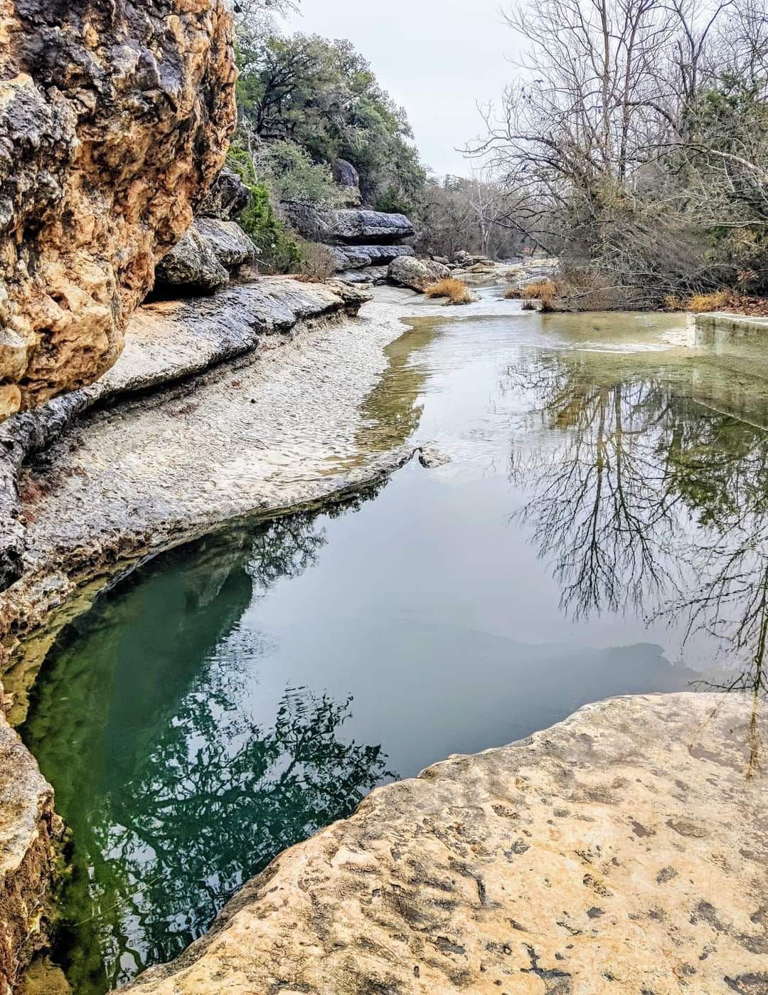
Some improvements have also been noted at the popular tourist spot Jacob’s Well, where swimming has been closed for the past two summers due to the low water levels and drought.
Recent photos taken on Wednesday from Metta Marie Archilla show that even though water levels are low, they have improved from last week.
Data from the USGS supports this, with the gauge height measuring in at almost 1.5 feet on Thursday (1/25). This is an improvement from the 0.25-foot gauge height prior to this week’s rain!
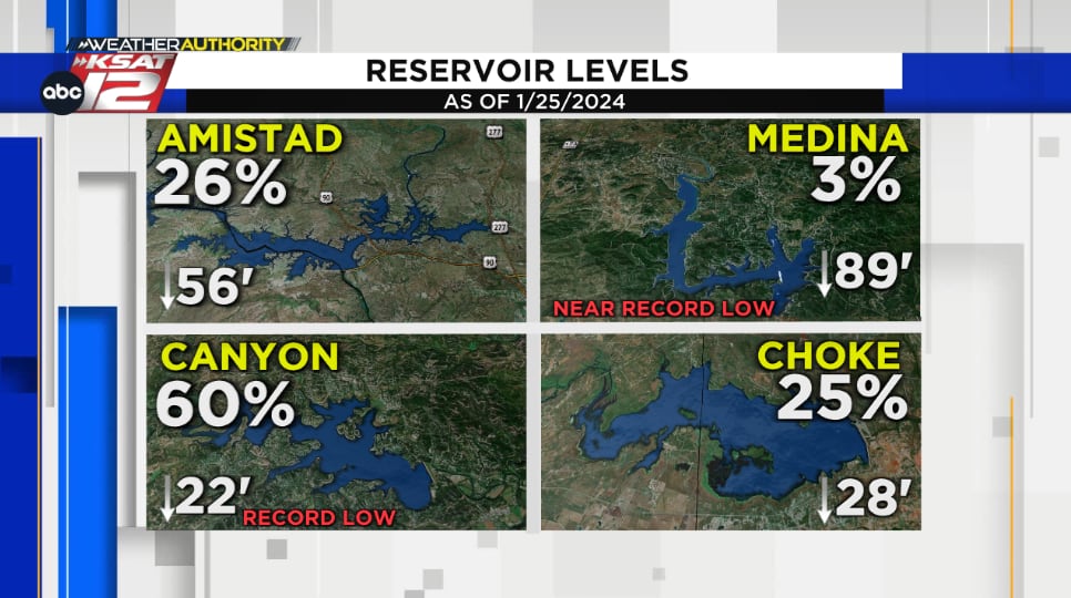
Lake Levels
It takes a lot more to fill up large bodies of water like our area’s lakes and reservoirs, so changes in lake levels haven’t been nearly as significant.
While small improvements have been found in bodies of water like Choke Canyon and Canyon Lake (which have both risen almost half of a foot in the past week), we still have a long way to go when it comes to filling these lakes back up.
On the flip side out west where rainfall totals weren’t nearly as impressive, Lake Amistad’s level unfortunately continues to fall.
Drought Monitor
The latest drought monitor was released Thursday morning and shows some improvements due to these recent rains!
While it only includes the rain from Sunday – Tuesday morning (data each week is cut off at 6 a.m. Tuesday for a Thursday release date), some of the extreme drought has been erased from Bexar, Comal, and Guadalupe counties, and severe drought has been erased from parts of Wilson County. Improvements have also been noted across portions of Lavaca, DeWitt, and Goliad counties, where moderate drought has been carved out.
Additional improvements are likely in next week’s update which will include the rest of the rain found in the Tuesday through Wednesday night timeframe.
Drought monitor improvements!
⬅️ This week's update
➡️ Last week's updateWhile this only includes Sunday – Tuesday morning's rain, extreme drought has been carved out of parts of Bexar, Comal & Guadalupe counties, along with severe drought carved out of parts of Wilson County pic.twitter.com/wLX8qPY3gL
— Mia Montgomery (@KSATMia) January 25, 2024
Moving Forward: Drier End to January
A quieter weather pattern takes over as we get ready to wrap up the month of January.
Morning fog & mist are expected into Friday morning, followed by just an isolated chance for a shower ahead of a front Friday night.
Drier air works in for the weekend followed by chilly mornings, comfortable afternoons, and no notable rain chances through the final days of the month.
- Read more from the meteorologists on the Whatever the Weather page
- Download KSAT’s weather app for customized, accurate forecasts in San Antonio, South Texas or wherever you are
- Find the latest forecasts, radar and alerts on the KSAT Weather Authority page