INTERACTIVE MAP: April 2024 total solar eclipse path
Monday, April 8, 2024, the path of a rare total solar eclipse will pass through Texas, including parts of San Antonio and the Hill Country around 1:30 p.m.
USING THE INTERACTIVE MAP: See if you will be in the path of totality, zoom into your neighborhood, or type your address using the magnifying glass on the top right of the map. If you are in the path of totality, the sky will turn dark and it will be safe to remove eye protection for the period mentioned in the map.
NOTICE: Only half of San Antonio is in the path of totality. If you are not in the path of totality, you will still experience a partial eclipse. The sky will still get dim, but it will NOT be safe at any point to remove eye protection during the eclipse.
Map was produced with data from NASA by KSAT Meteorologist Sarah Spivey.
ASK: What questions do you have about the eclipse?
Here’s a breakdown of how long totality will last in your neighborhood:
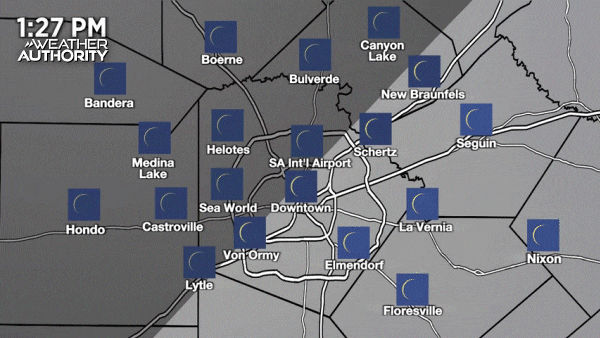
SAN ANTONIO METRO AREA
EVENTS: Here’s a list of South Texas events for viewing April’s total eclipse
BEXAR COUNTY (Half of Bexar County in path of totality, Downtown San Antonio NOT in the path of totality)
| LOCATION | TOTALITY BEGINS | TOTALITY DURATION |
|---|---|---|
| Fair Oaks Ranch | 1:33:02 p.m. | 3 minutes, 13 seconds |
| Government Canyon | 1:32:41 p.m. | 2 minutes, 57 seconds |
| Leon Springs | 1:33:06 p.m. | 2 minutes, 51 seconds |
| Dominion | 1:33:09 p.m. | 2 minutes, 46 seconds |
| Helotes | 1:32:56 p.m. | 2 minutes, 38 seconds |
| The Rim | 1:33:15 p.m. | 2 minutes, 29 seconds |
| Alamo Ranch | 1:32:49 p.m. | 2 minutes, 27 seconds |
| UTSA | 1:33:12 p.m. | 2 minutes, 25 seconds |
| Timberwood Park | 1:33:36 p.m. | 2 minutes, 23 seconds |
| Eisenhower Park | 1:33:29 p.m. | 2 minutes, 14 seconds |
| Westover Hills (SeaWorld Area) | 1:33:02 p.m. | 2 minutes, 5 seconds |
| Shavano Park | 1:33:30 p.m. | 2 minutes, 2 seconds |
| Leon Valley | 1:33:20 p.m. | 1 minute, 50 seconds |
| Stone Oak | 1:33:53 p.m. | 1 minute, 50 seconds |
| Hollywood Park | 1:33:48 p.m. | 1 minute, 43 seconds |
| Medical Center | 1:33:30 p.m. | 1 minute, 42 seconds |
| Castle Hills | 1:33:53 p.m. | 1 minute, 10 seconds |
| Balcones Heights | 1:33:47 p.m. | 1 minute, 9 seconds |
| San Antonio Int’l Airport | 1:34:16 p.m. | 36 seconds |
| JBSA Lackland | 1:33:58 p.m. | 12 seconds |
| Alamo Heights | NOT IN THE PATH OF TOTALITY, Partial eclipse | |
| China Grove | NOT IN THE PATH OF TOTALITY, Partial eclipse | |
| Converse | NOT IN THE PATH OF TOTALITY, Partial eclipse | |
| Downtown San Antonio | NOT IN THE PATH OF TOTALITY, Partial eclipse | |
| Elmendorf | NOT IN THE PATH OF TOTALITY, Partial eclipse | |
| The Quarry/Olmos Park/San Antonio Zoo | NOT IN THE PATH OF TOTALITY, Partial eclipse | |
| Schertz/Selma/Cibolo | NOT IN THE PATH OF TOTALITY, Partial eclipse | |
| Somerset | NOT IN THE PATH OF TOTALITY, Partial eclipse | |
| Von Ormy | NOT IN THE PATH OF TOTALITY, Partial eclipse | |
| Woodlawn Lake | NOT IN THE PATH OF TOTALITY, Partial eclipse |
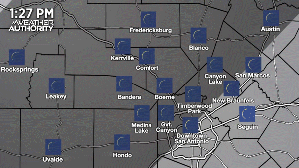
COMAL COUNTY (Majority of Comal County in path of totality)
| LOCATION | TOTALITY BEGINS | TOTALITY DURATION |
|---|---|---|
| Spring Branch | 1:33:45 p.m. | 3 minutes, 0 seconds |
| Mystic Shores at Canyon Lake | 1:34:08 p.m. | 2 minutes, 47 seconds |
| Bulverde | 1:33:43 p.m. | 2 minutes, 28 seconds |
| Smithson Valley | 1:34:08 p.m. | 2 minutes, 16 seconds |
| Startzville | 1:34:23 p.m. | 2 minutes, 6 seconds |
| Canyon Lake Dam | 1:34:44 p.m. | 1 minute, 41 seconds |
| Garden Ridge | NOT IN THE PATH OF TOTALITY, Partial eclipse | |
| New Braunfels/Gruene | NOT IN THE PATH OF TOTALITY, Partial eclipse |
GUADALUPE COUNTY (None of Guadalupe County is in the path of totality. A partial eclipse will still be visible)
KENDALL COUNTY (All of Kendall County will be in path of totality)
| LOCATION | TOTALITY BEGINS | TOTALITY DURATION |
|---|---|---|
| Comfort | 1:32:29 p.m. | 4 minutes, 12 seconds |
| Waring | 1:32:42 p.m. | 4 minutes, 3 seconds |
| Sisterdale | 1:32:55 p.m. | 3 minutes, 58 seconds |
| Boerne | 1:32:47 p.m. | 3 minutes, 35 seconds |
| Kendalia | 1:33:47 p.m. | 3 minutes, 33 seconds |
| Bergheim | 1:33:16 p.m. | 3 minutes, 16 seconds |
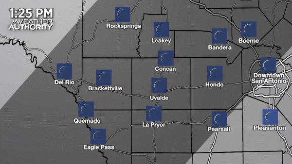
MEDINA COUNTY (Majority of Medina County in path of totality)
| LOCATION | TOTALITY BEGINS | TOTALITY DURATION |
|---|---|---|
| D’Hanis | 1:31:01 p.m. | 3 minutes, 41 seconds |
| Medina Lake Dam | 1:32:06 p.m. | 3 minutes, 24 seconds |
| Hondo | 1:31:26 p.m. | 3 minutes, 23 seconds |
| Rio Medina | 1:32:16 p.m. | 2 minutes, 53 seconds |
| Castroville | 1:32:21 p.m. | 2 minutes, 27 seconds |
| Natalia | 1:32:56 p.m. | 48 seconds |
| Devine | 1:32:47 p.m. | 45 seconds |
HILL COUNTRY
KERR COUNTY (All of Kerr County in path of totality)
| LOCATION | TOTALITY BEGINS | TOTALITY DURATION |
|---|---|---|
| Ingram | 1:31:59 p.m. | 4 minutes, 27 seconds |
| Hunt | 1:31:49 p.m. | 4 minutes, 26 seconds |
| Kerrville | 1:32:07 p.m. | 4 minutes, 25 seconds |
| Mountain Home | 1:31:58 p.m. | 4 minutes, 23 seconds |
| Center Point | 1:32:10 p.m. | 4 minutes, 18 seconds |
BANDERA COUNTY (All of Bandera County in path of totality)
| LOCATION | TOTALITY BEGINS | TOTALITY DURATION |
|---|---|---|
| Lost Maples State Natural Area | 1:30:59 p.m. | 4 minutes, 27 seconds |
| Medina | 1:31:33 p.m. | 4 minutes, 21 seconds |
| Bandera | 1:31:51 p.m. | 4 minutes, 5 seconds |
| Pipe Creek | 1:32:12 p.m. | 3 minutes, 50 seconds |
| Lakehills | 1:32:05 p.m. | 3 minutes, 33 seconds |
REAL COUNTY (All of Real County in path of totality)
| LOCATION | TOTALITY BEGINS | TOTALITY DURATION |
|---|---|---|
| Leakey | 1:30:31 p.m. | 4 minutes, 26 seconds |
| Camp Wood | 1:30:04 p.m. | 4 minutes, 20 seconds |
GILLESPIE COUNTY (All of Gillespie County in path of totality)
| LOCATION | TOTALITY BEGINS | TOTALITY DURATION |
|---|---|---|
| Enchanted Rock (Llano/Gillespie County Line) | 1:33:25 p.m. | 4 minutes, 26 seconds |
| Fredericksburg | 1:32:57 p.m. | 4 minutes, 25 seconds |
| Harper | 1:32:23 p.m. | 4 minutes, 22 seconds |
| Luckenbach | 1:33:03 p.m. | 4 minutes, 17 seconds |
EDWARDS COUNTY (Majority of Edwards County in path of totality)
| LOCATION | TOTALITY BEGINS | TOTALITY DURATION |
|---|---|---|
| Barksdale | 1:30:09 p.m. | 4 minutes, 16 seconds |
| Rocksprings | 1:30:48 p.m. | 3 minutes, 24 seconds |
| Carta Valley | 1:30:02 p.m. | 2 minutes, 38 seconds |
UVALDE COUNTY (All of Uvalde County in path of totality)
| LOCATION | TOTALITY BEGINS | TOTALITY DURATION |
|---|---|---|
| Garner State Park | 1:30:19 p.m. | 4 minutes, 27 seconds |
| Concan | 1:30:12 p.m. | 4 minutes, 26 seconds |
| Uvalde | 1:29:40 p.m. | 4 minutes, 16 seconds |
| Knippa | 1:30:10 p.m. | 4 minutes, 11 seconds |
| Sabinal | 1:30:35 p.m. | 4 minutes, 0 seconds |
SOUTH TEXAS PLAINS
VAL VERDE COUNTY (Some of Val Verde County in path of totality)
| LOCATION | TOTALITY BEGINS | TOTALITY DURATION |
|---|---|---|
| Laughlin AFB | 1:28:32 p.m. | 3 minutes, 44 seconds |
| Del Rio | 1:28:29 p.m. | 3 minutes, 28 seconds |
| Amistad Village | 1:28:52 p.m. | 2 minutes, 38 seconds |
| Loma Alta | 1:30:53 p.m. | 1 minute, 2 seconds |
| Devil’s River State Natural Area | NOT IN THE PATH OF TOTALITY, Partial eclipse |
KINNEY COUNTY (All of Kinney County in path of totality)
| LOCATION | TOTALITY BEGINS | TOTALITY DURATION |
|---|---|---|
| Spofford | 1:28:29 p.m. | 4 minutes, 25 seconds |
| Brackettville | 1:28:46 p.m. | 4 minutes, 20 seconds |
| Kickapoo Cavern State Park | 1:29:29 p.m. | 3 minutes, 52 seconds |
MAVERICK COUNTY (All of Maverick County will be in path of totality)
| LOCATION | TOTALITY BEGINS | TOTALITY DURATION |
|---|---|---|
| Quemado | 1:27:44 p.m. | 4 minutes, 26 seconds |
| Eagle Pass | 1:27:31 p.m. | 4 minutes, 25 seconds |
| El Indio | 1:27:42 p.m. | 4 minutes, 0 seconds |
ZAVALA COUNTY (Most of Zavala County in path of totality)
| LOCATION | TOTALITY BEGINS | TOTALITY DURATION |
|---|---|---|
| La Pryor | 1:29:16 p.m. | 3 minutes, 54 seconds |
| Batesville | 1:29:52 p.m. | 3 minutes, 32 seconds |
| Crystal City | 1:29:09 p.m. | 3 minutes, 19 seconds |
DIMMIT COUNTY (Half of Dimmit Countyin path of totality)
| LOCATION | TOTALITY BEGINS | TOTALITY DURATION |
|---|---|---|
| Carrizo Springs | 1:29:03 p.m. | 2 minutes, 51 seconds |
| Asherton | 1:29:32 p.m. | 1 minute, 55 seconds |
| Big Wells | 1:30:20 p.m. | 1 minute, 25 seconds |
FRIO COUNTY (Half of Frio County in path of totality)
| LOCATION | TOTALITY BEGINS | TOTALITY DURATION |
|---|---|---|
| Frio Town | 1:30:55 p.m. | 2 minutes, 44 seconds |
| Moore | 1:32:22 p.m. | 56 seconds |
| Pearsall | NOT IN THE PATH OF TOTALITY, Partial eclipse |
- KSAT Q&A: NASA project scientist answers questions about next month’s total solar eclipse
- Read more from the meteorologists on the Whatever the Weather page
- Download KSAT’s weather app for customized, accurate forecasts in San Antonio, South Texas or wherever you are
- Find the latest forecasts, radar and alerts on the KSAT Weather Authority page