FORECAST HIGHLIGHTS
- HOT & HUMID TODAY: Temps mid-90s, heat index near 100
- TUESDAY: Storms Tuesday night along Rio Grande, mainly west of SA
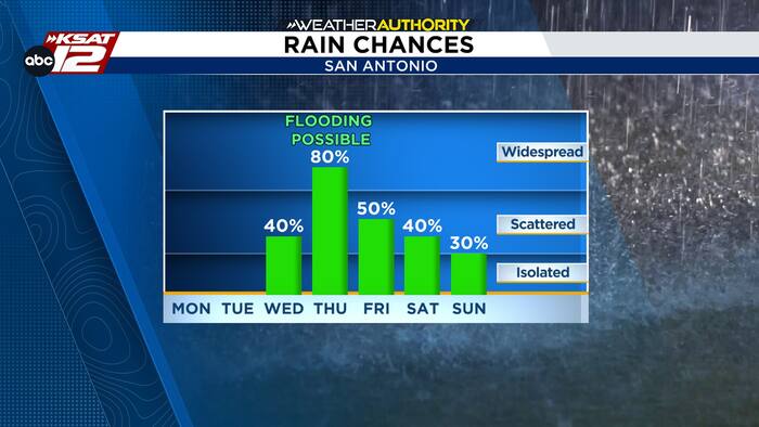
- WEDNESDAY: Line of storms Wednesday night, some strong, heavy rain approaching San Antonio
- THURSDAY: Storms continue, heavy rain, flood threat
- FRIDAY: Rain chances linger, cooler
FORECAST
TODAY
We are now just a few days away from changes, however, today will still be hot. Expect a high in the mid-90s, with a heat index near 100°.
TUESDAY
San Antonio will see partly cloudy and hot conditions on Tuesday, too. But, as the remnants of Polo moves north, a line of storms may develop across West Texas. This line is forecast to reach the Rio Grande late Tuesday night into very early Wednesday and bring rain to areas west of SA. This line likely dies down before reaching San Antonio.

WEDNESDAY NIGHT — ⚠ FLOODING POSSIBLE ⚠
By Wednesday evening, another line of storms will take shape along a slow-moving front and move east. This line will be capable of producing some strong storms, but the main threat will be heavy rainfall. As of now, this line of storms is forecast to reach San Antonio pre-dawn on Thursday.

THURSDAY — ⚠ FLOODING POSSIBLE ⚠
Storms are forecast to continue through at least the first half of the day on Thursday. Should we see storms tracking over the same areas, flooding would be a concern. This is a timeframe we will watch closely.


FRIDAY AND BEYOND
Showers may linger into Friday and potentially the weekend. Clouds and rain chances will keep temperatures down.

QUICK WEATHER LINKS
- WATCH LIVE: Doppler Radar
- Hourly and 10-Day Forecast
- Download FREE KSAT Weather Authority App: Up-to-date forecast information and livestreams from trusted local meteorologists.
- KSAT Connect: Share your weather photos.