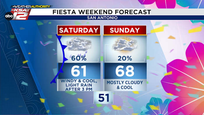
FORECAST HIGHLIGHTS
- TEMPS TODAY: Falling into the 50s by sunset
- BEST RAIN CHANCES: After 3 pm Saturday
-
- IMPACT: Minimal lightning, no severe weather
- FIESTA PLANS? Don’t cancel, but bring umbrella
- SUNDAY/MONDAY: Mostly cloudy & cool, rounds of light rain
- REST OF NEXT WEEK: Gradually warming
FORECAST
SATURDAY

As expected, a cold front has moved through San Antonio, and temps will be falling the rest of the day. Here’s what you can expect:
- Gusts of up to 35-40 mph out of the north
- Falling temperatures: 50s by sunset
- Areas of light rain
A few rumbles of thunder are also possible with Saturday afternoon’s activity, but dangerous severe weather is NOT expected. If you have outdoor or Fiesta plans, just bring an umbrella or poncho with you!
SUNDAY
Most of the rain Sunday will stay well south of San Antonio. There will be some peeks of sun, and temps will stay cool — in the 60s. Clouds will thicken Sunday night, with a few sprinkles possible.
MONDAY

An upper-level disturbance will bring another round of showers. While the rain won’t be heavy, off and on showers are possible throughout the day. This will keep temperatures cool, with highs struggling to get out of the 50s. Showers may try to wind down a bit in time for the Texas Cavaliers River Parade, but plan for cool & damp conditions.
EXTENDED FORECAST
From Tuesday on, it’ll gradually warm. We’ll be monitoring a small storm chance for Battle of Flowers.

QUICK WEATHER LINKS
- WATCH LIVE: Doppler Radar
- Hourly and 10-Day Forecast
- Download FREE KSAT Weather Authority App: Up-to-date forecast information and livestreams from trusted local meteorologists.
- KSAT Connect: Share your weather photos.