FORECAST HIGHLIGHTS
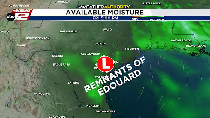
- REMNANTS OF EDOUARD: Leftover moisture will bring a few isolated downpours Thu/Fri
- HOT LABOR DAY WEEKEND: Upper-90s, humidity
- NO FRONT IN SIGHT: Hot through mid-September
FORECAST
TODAY
Wednesday will be hot & quiet. That said, like Tuesday, a few showers could affect those areas east of San Antonio. Highs will reach the upper-90s this afternoon.
THURSDAY/FRIDAY RAIN CHANCE
Meantime Edouard will continue to weaken as it moves north toward Dallas today. By Thursday and Friday, the remnants of Edouard will get pulled southwest toward San Antonio. With some leftover moisture, isolated to widely scattered showers are possible Thursday and Friday. Rainfall totals should generally be light, but a few heavier downpours can’t be ruled out.

HOT LABOR DAY WEEKEND
Any rain chance will end by Saturday, leaving us hot and dry for the Labor Day weekend. Highs will remain in the upper-90s. Temperatures are showing few signs of relenting, meaning above-average temps will continue into mid-September.

QUICK WEATHER LINKS
- WATCH LIVE: Doppler Radar
- Hourly and 10-Day Forecast
- Download FREE KSAT Weather Authority App: Up-to-date forecast information and livestreams from trusted local meteorologists.
- KSAT Connect: Share your weather photos.