FORECAST HIGHLIGHTS
- COLD FRONT SUNRISE WEDNESDAY: Gusty winds of up to 35 mph, much cooler
- NICE THANKSGIVING: Comfortable & sunny, highs in the 60s
- ACTIVE PATTERN: By late Friday into Saturday, rain returns to the forecast, colder by Sunday
FORECAST
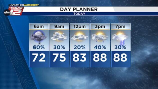
It was a warm day today, with a high in the 80s…close to a record!
COLD FRONT EARLY TOMORROW

A cold front sweeps through early tomorrow, bringing cooler weather and gusty winds for the first half of Wednesday. Gusts of up to 35 mph are possible. Temperatures on Wednesday will be in the 60s…15-20 degrees cooler than today!. It’ll stay sunny.
THANKSGIVING DAY
Thanksgiving could be the nicest day of our entire forecast. We are calling for sunny skies and highs near 70. Picture perfect!

FRIDAY AND INTO THE WEEKEND
Clouds quickly fill in on Friday and by Saturday, we’ll have rain chances returning to the forecast. A strong front is set to arrive Sunday morning, dropping temperatures for the second half of the weekend. Light showers will be possible Sunday and Monday, while temperatures will be cool. Our coldest morning yet may arrive Tuesday.

QUICK WEATHER LINKS
- WATCH LIVE: Doppler Radar
- Hourly and 10-Day Forecast
- Download FREE KSAT Weather Authority App: Up-to-date forecast information and livestreams from trusted local meteorologists.
- KSAT Connect: Share your weather photos.