FORECAST HIGHLIGHTS
- CHILLY MORNINGS: 40s around San Antonio Saturday and Sunday
- PLEASANT AFTERNOONS: Upper 60s to near 70 Saturday, warmer Sunday
- WARMING NEXT WEEK: Afternoon highs warm into the 80s
- STAYING DRY: No rain currently in the forecast
FORECAST
FIRST COLD FRONT OF THE SEASON IN THE BOOKS

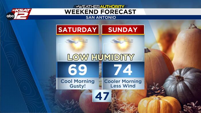
This cool weather has brought us all the relief we have been waiting for!! We can officially say we’ve had the first cold front of fall, which did arrive later than the average September 23 date, but at least it was earlier than the first front in 2025! Today, Saturday, has been the coolest day since fall began with a low of 51 and high of 69. However, we are expecting to have our actual coolest fall morning on Sunday, before a warming trend starts again.
ANOTHER COOL START
With lighter winds and mostly clear conditions Saturday night, temperatures will tumble again by Sunday morning. San Antonio and the surrounding areas can expect lows in the 40s, with Hill Country areas having the coolest start.

Sunday afternoon turns pleasantly mild, with lighter winds, plenty of sunshine and temperatures climbing into the 70s.
GRADUAL WARM UP
Temperatures will steadily climb next week with no rain in the forecast. Highs reach the 70s to near 80 by Monday, and moving to the mid 80s by Thursday. Morning lows gradually rise from the 40s and 50s into the 60s by Friday.

QUICK WEATHER LINKS
- WATCH LIVE: Doppler Radar
- Hourly and 10-Day Forecast
- Download FREE KSAT Weather Authority App: Up-to-date forecast information and livestreams from trusted local meteorologists.
- KSAT Connect: Share your weather photos.