FORECAST HIGHLIGHTS
- FLOOD WATCH: In effect tonight through Thursday
- BEXAR COUNTY: Intermittent rain tonight through Friday morning
-
- AMOUNTS: Widespread 1″ to 3″, Bullseyes: 6″+
- RISKS: Street & creek flooding, lightning
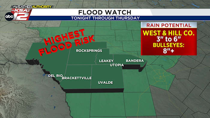
- WEST & HILL COUNTRY: Highest rain potential, Bullseyes 8″+
-
- RISKS: River & street flooding
-
- RIVERS ON ALERT: Rio Grande, Nueces, Frio, & Sabinal
FORECAST

An active pattern is taking shape across South Texas. Disturbances, combined with a boundary and ample moisture, will create a flood risk.
WHEN: Tonight through Thursday
CONCERN: Street flooding in urban areas. River and creek flooding will also be possible, mainly west of San Antonio. If you live or plan to be along any area river, make sure alerts are turned on your phone and you remain weather aware.
HOW MUCH RAINFALL?
- SAN ANTONIO: Widespread 1-3″ over the next four days, however, some spots could see more than 6″
- WEST & HILL COUNTRY: Higher totals, Some bullseyes over 8″ to 10″
TONIGHT & TUESDAY MORNING
Rain, heavy at times, should become widespread overnight then periodically come and go through Friday morning.
In this type of setup, it’s impossible to know where the heaviest of the rainfall will be, but flash flooding will be a concern at any point through Thursday night. The Tuesday morning commute is likely to be affected by rain, but we’ll have to wait and see where where street flooding becomes an issue.
TUESDAY

Heavy rainfall is forecast to continue into Tuesday, with a few breaks in the action during the day. Odds favor most of the rain to be focused in the morning hours, but some redevelopment in the late afternoon & evening will be possible.
WEDNESDAY & THURSDAY
More heavy rain is forecast to setup in the area Wednesday and Thursday, with the focus slowly shifting west towards the Rio Grande. Rainfall totals of up to 3-6″ will be possible, with some isolated spots seeing more than 8″ in and around the Rio Grande and Edwards Plateau areas. River flooding will be a concern and will be closely monitored. Those who live or have plans to be near the Frio, Nueces or Rio Grande should pay particularly close attention to the forecast.

THURSDAY AFTERNOON THROUGH WEEKEND
While some lingering rain is possible Thursday afternoon, for the most part activity will wind down. Only spotty rain is possible over the weekend.

QUICK WEATHER LINKS
- WATCH LIVE: Doppler Radar
- Hourly and 10-Day Forecast
- Download FREE KSAT Weather Authority App: Up-to-date forecast information and livestreams from trusted local meteorologists.
- KSAT Connect: Share your weather photos.