FORECAST HIGHLIGHTS
- HOT & HUMID: Highs near 90 today
- 10AM SATURDAY COLD FRONT: Gusty winds, falling temps, and showers
- BEST RAIN CHANCES: Saturday afternoon & night, again on Monday
FORECAST
TODAY
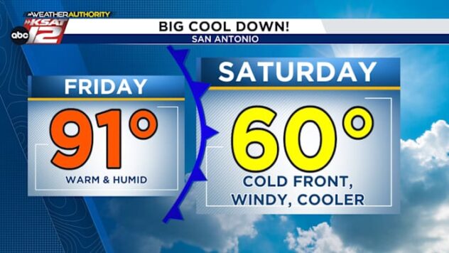
An overcast morning will give way to afternoon sunshine. Expect a hot day, with a high near 90.
SATURDAY
After a mild morning in the 70s, a cold front will slide through San Antonio around 10am. With the front you can expect:
- Gusts of up to 35-40 mph out of the north
- Falling temperatures (low-60s by the afternoon)
- Rain, especially Saturday afternoon and evening
A few rumbles of thunder are also possible with Saturday afternoon’s activity. Showers should wind down by sunrise Sunday.

SUNDAY
Sunday should be drier, with some peeks of sun during the afternoon. It’ll stay mild, with highs in the low-70s. Clouds will thicken Sunday night, with a few sprinkles possible.

MONDAY
An upper-level disturbance will bring another round of showers. While the rain won’t be heavy, off and on showers are possible throughout the day. This will keep temperatures cool, with highs only in the low-60s. Showers may try to wind down a bit in time for the Texas Cavaliers River Parade, but plan for cool & damp conditions.

EXTENDED FORECAST

QUICK WEATHER LINKS
- WATCH LIVE: Doppler Radar
- Hourly and 10-Day Forecast
- Download FREE KSAT Weather Authority App: Up-to-date forecast information and livestreams from trusted local meteorologists.
- KSAT Connect: Share your weather photos.