FORECAST HIGHLIGHTS
- SUNDAY: Frigid start, mild afternoon
- WARMING UP: Warmer, more seasonable
- RAIN CHANCES: Possible, but low odds
FORECAST
FRIGID MORNING
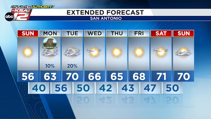
Much of the area is waking up frigid this morning. Temperatures are expected to stay below freezing until mid morning. Remember to dress warm if you are going out this morning!

These bitter conditions won’t last all day, though. Once the sun comes up, sunny skies and light winds will help push temperatures up into the 50s.
SPOTTY SHOWERS
Looking ahead, a weak upper-level disturbance is forecast to bring a few spotty showers into the San Antonio area Monday evening. Any rain is likely to be brief and light, with showers moving in from the west and drifting east through the night. By early Tuesday morning, rain chances are expected to end.

STAYING WARM
Highs are expected to jump to 70 degrees by Tuesday, staying well above freezing at night for most of the upcoming week. Another front moves through Tuesday night into Wednesday, but temperatures are only forecast to slip to the low to mid-60s the rest of the week.

QUICK WEATHER LINKS
- WATCH LIVE: Doppler Radar
- Hourly and 10-Day Forecast
- Download FREE KSAT Weather Authority App: Up-to-date forecast information and livestreams from trusted local meteorologists.
- KSAT Connect: Share your weather photos.