FORECAST HIGHLIGHTS
- PATCHY AM FOG: brief fog through 8am, then sunny
- COLD FRONT: arrives early Sunday with gusty winds and much cooler air
- CHILLY: mid 30s Monday morning … the coldest air yet this fall
FORECAST
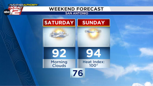
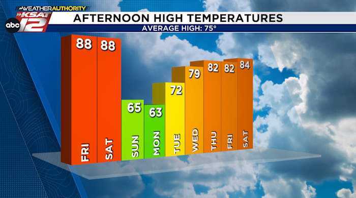
NEAR-RECORD HIGHS FRIDAY & SATURDAY
Record highs will be challenged Friday and Saturday with afternoon temperatures in the upper 80s/near 90°. Then the cold front arrives changing everything on Sunday.
SUNDAY PLUNGE, FIRE DANGER
A strong cold front arrives just after midnight Sunday. Temperatures will still be mild Sunday morning (upper 50s), however, we won’t see much warming during the day with highs only in the mid 60s. Also, it’ll be a windy day with gusts up to 45 mph – especially in the morning. The combination of gusty winds, low humidity, and drought conditions will make for a very high fire danger. Temps then fall into the 30s by Monday morning.

QUICK WEATHER LINKS
- WATCH LIVE: Doppler Radar
- Hourly and 10-Day Forecast
- Download FREE KSAT Weather Authority App: Up-to-date forecast information and livestreams from trusted local meteorologists.
- KSAT Connect: Share your weather photos.