FORECAST HIGHLIGHTS:
- No rain, hot temperatures, and heat index values 100°+ this week
- Saharan dust noticeable through Thursday
- Slight chance of rain Sunday
- Possible development in the tropics
FORECAST:
Typical late July/early August temperatures with afternoons in the mid to upper 90s. So far this summer we’ve had 12 triple digit days, which is nothing compared to this time last year with 34 days and two years ago 50.
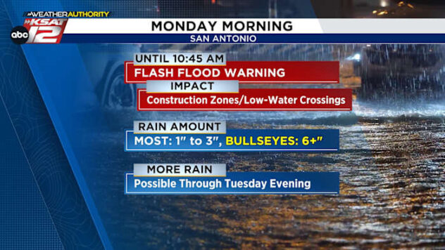
The upper-level “heat high” drifts away from Texas a bit Sunday opening the door for rainmaking energy to move in, potentially developing showers/storms. As of now, it’s just a 30% chance.
Hazy African dust crept into our sky today and will get more noticeable tomorrow and Thursday. By Friday it should clear out.
It’s suspended high in atmosphere and only small concentrations make it down to the surface, but it’s possible that it could affect those who are sensitive to dust. The biggest impacts are a hazy sky and colorful sunrises and sunsets.

Lastly, the tropics are forecast to become active again. Indications are that a wave, currently over the Atlantic, will start to organize in the coming days. It’s far too early to talk specifics, but for now, those in the northern Caribbean and Florida will want to watch what unfolds.