HIGHLIGHTS:
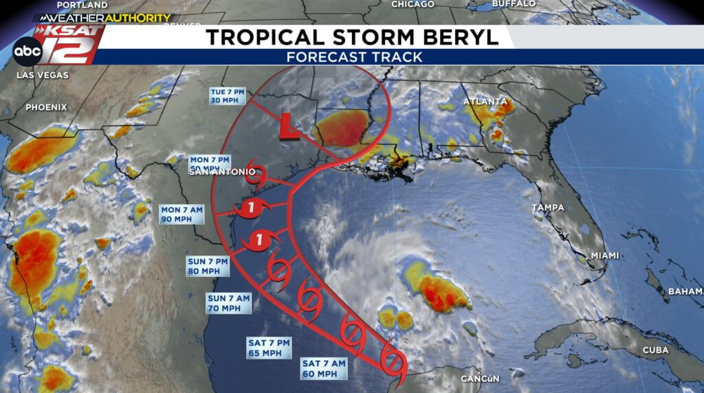
- By Sunday, all eyes will be on the southern Texas coast as Beryl gets close to making landfall
- The storm is expected to be near hurricane strength when it makes landfall Monday morning. As of Friday evening, it is a tropical storm
- A shift north in its position overnight has shifted Beryl’s potential track farther east.
- This means rainfall will vary SIGNIFICANTLY across our area. Higher totals favor those farther east, with much lower totals farther west, and potentially even here in San Antonio.
CHANGES IN BERYL’S PATH:
As we’ve been stressing, tropical activity can often throw you a curve ball and paths can change. So is the case with Beryl.
A repositioning of the center of circulation to the north is resulting in a change in the potential path. As of Friday evening, the latest update curves Beryl more to the northeast as it approaches the southern Texas coast.

There are a couple of important points with this new development. One is that if it were to stay over water a little bit longer (ride the Texas coast vs. moving inland), then further intensification may become an issue.
This could bring direct impacts as far north as Corpus Christi/Matagorda Bay. Additionally, this would place San Antonio on the drier side of the storm, resulting in lower rainfall totals.

Beryl’s exact track will be very important going forward and we’ll still need to wait for the storm to re-emerge into the Gulf before making any real assumptions. The potential path will continue to shift. However, in this kind of setup, know that rainfall totals will vary widely: little to no rain to the west, with heavy, significant rainfall to the east. Any small deviation in the track, and we’re talking a matter of miles, can change this scenario (remember Hurricane Harvey’s rainfall pattern over South/Central Texas).
Bottom line: keep checking back for more updates! We’ll be tracking this very closely through the weekend.
YOUR KSAT WEATHER AUTHORITY
Download the KSAT 12 Weather App on your smartphone for the latest weather updates. You can also keep up with forecasts, livestreams and interactive maps on KSAT.com.
Want to share what you’re seeing with KSAT12′s meteorologists? Submit photos and videos here, and your submission may get featured on KSAT.com or on air.
RESOURCES:
- San Antonio nonprofits prepare to head to the Texas coast for Beryl aftermath
- Texas officials urge preparation, not panic ahead of Beryl
- Severe weather in Bexar County? Find resources to keep you safe here
- Prepare for heavy rainfall with these best practices
- Keep an eye out! Tips to help you spot severe weather scams, prevent them
- Salvation Army prepares for potential impacted areas Hurricane Beryl may cause in Texas
- Download the KSAT Weather App for hyperlocal, accurate weather information
- Weather Alerts