FORECAST HIGHLIGHTS
- FRIDAY: Near 100° with heat indices up to 106°
- LORENA REMNANTS: Leftover moisture and rain-making energy move into Texas this weekend
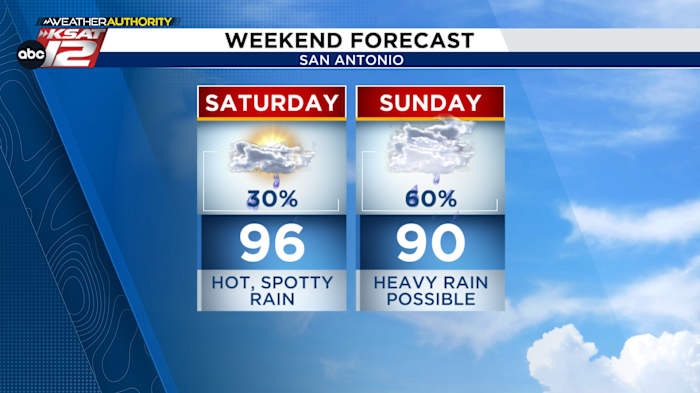
- RAIN: Scattered second half of the weekend, especially Sunday into Monday
- RAINFALL TOTALS & UNCERTAINTY: Localized heavy rain could create bullseyes of 5″+, but exact locations still unclear
FORECAST
HEATING UP
South-Central Texas will experience dry, sunny skies and highs near 100° Friday. While most areas remain dry, a few isolated showers could develop late in the day over the southern Edwards Plateau as tropical moisture approaches.
LORENA & WEEKEND RAIN

While Lorena continues to weaken more and more, its remnant moisture and upper-level energy is being pulled into Texas by strong subtropical jet winds. This, combined with a front moving south, will increase the potential for scattered showers and storms across the region Saturday through Monday.
UNCERTAINTY & LOCALIZED IMPACTS

The exact location of the heaviest rainfall this weekend remains uncertain, making it a bit of a “rain lottery” across South-Central Texas. Some areas could see intense downpours while others stay relatively dry. Localized flooding is a concern, especially in low-lying zones or spots with poor drainage. The entire area is under a marginal flash flood risk from Sunday through Monday morning.
Please check back as we’ll continue to update this forecast.

QUICK WEATHER LINKS
- WATCH LIVE: Doppler Radar
- Hourly and 10-Day Forecast
- Download FREE KSAT Weather Authority App: Up-to-date forecast information and livestreams from trusted local meteorologists.
- KSAT Connect: Share your weather photos.