WATCH LIVE RADAR IN VIDEO ABOVE
FORECAST HIGHLIGHTS
- FLOOD WATCH: Monitoring the risk for *isolated* flooding
- SPOTTY DOWNPOURS: 30-40% chance each day
- HOT & HUMID: Otherwise feeling like 100°
- NEXT WEEK: Quieter & hot
FORECAST

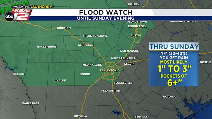
While the weekend will be mainly hot and humid, there is a daily chance for rain, too. Because the ground is so saturated from recent floods, we’ll have to monitor for isolated incidents of flooding, especially across the Hill Country. A FLOOD WATCH has been issued for the Hill Country and north Bexar County until Sunday evening
WATCH: What’s the difference between a WATCH & WARNING?
SATURDAY
While most of the rainfall this weekend will be manageable, there is a small chance that some heavier rain could shift into the Hill Country.
West Texas and North Texas will have the highest odds for heavy rain on Saturday, with more isolated rainfall expected in South-Central Texas. With recovery operations still underway in Kerr County, we’ll be paying close attention to any rainfall in and around the Hill Country. Rain chances in San Antonio sit at 30%.
SATURDAY NIGHT

A cluster of storms will begin to build over the Edwards Plateau near San Angelo and Abilene Saturday evening. This is what we are watching closely as it has the potential to move into the Hill Country overnight. The placement we are watching is the Southern Edwards Plateau, I-35 and mainly North of I-10 through Sunday Morning.
FEW STORMS SUNDAY
Any afternoon downpours that form will depend on the earlier activity. Expect showers capable to produce localized heavy rainfall and another chance of a isolated flood threat. Rain chance in San Antonio is 30%.
DRIER, HOTTER NEXT WEEK
The heat high does shift into the area starting Monday. This will eliminate rain chances and up daily high temperatures.

QUICK WEATHER LINKS
- WATCH LIVE: Doppler Radar
- Hourly and 10-Day Forecast
- Download FREE KSAT Weather Authority App: Up-to-date forecast information and livestreams from trusted local meteorologists.
- KSAT Connect: Share your weather photos.