FORECAST HIGHLIGHTS
- THIS WEEKEND: Warm & Quiet across Texas for travel
- GUSTY WINDS: Secure yard decorations, winds can gust up to 40 mph
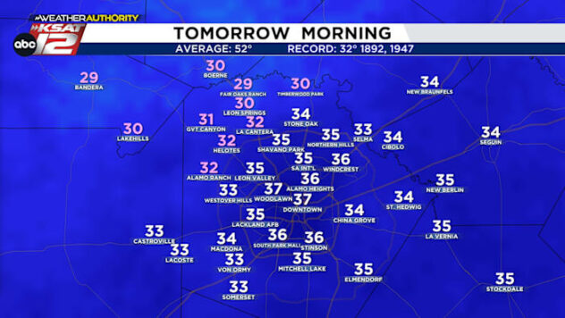
- MORNINGS: Temps drop to the 30s, wind gusts up to 40 mph
- NEW YEARS: Looking chilly & quiet
FORECAST
SUNDAY
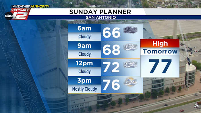
We’ll see some fog out west early Sunday morning, clearing up by 9am. It stays cloudy afterwards with only a few peeks of sun in the afternoon. Highs hit the upper 70s again in the afternoon.


COLD FRONT
A strong cold front is expected to move through San Antonio late Sunday night. Temperatures decrease into the the 30s & 40s Monday morning for many with a slight rain chance for some.

However, the main story will be the winds. Secure loose holiday decorations Sunday before the front arrives as winds could gust up to 40 mph.


NEW YEARS
After the front moves through, colder air sticks around to end 2025. Wednesday will be the coldest morning, as some areas could get down to freezing outside of Bexar County. Afterwards, we’ll have a warming trend as we begin 2026!

QUICK WEATHER LINKS
- WATCH LIVE: Doppler Radar
- Hourly and 10-Day Forecast
- Download FREE KSAT Weather Authority App: Up-to-date forecast information and livestreams from trusted local meteorologists.
- KSAT Connect: Share your weather photos.