FORECAST HIGHLIGHTS
- TROPICS: Chance of development in the Gulf has passed, mainly just a sprinkle & clouds for San Antonio
- DROUGHT MONITOR: Notable improvement in many areas
- TRIPLE DIGIT HEAT: A mostly dry forecast with near triple digit heat
FORECAST
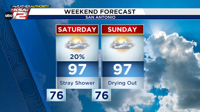
TROPICS – SMALL RAIN CHANCE
Upper-level energy with Gulf moisture is moving into southeast Texas and will cause rain from the Louisiana Coast to Houston. We are not expecting major impacts here, if any at all. More than anything we’ll have a wider variety of clouds and possibly a stray shower today into early Saturday- especially in our eastern counties.

DROUGHT MONITOR
We’ve been keeping a close eye on the drought monitor. Despite the devastating July 4th floods and rising river levels—including the Nueces River—some areas, like Medina County, are still in exceptional drought conditions.
The drought monitor factors in more than just rain. It also looks at soil moisture, aquifers, and lake levels. While other regions improved, Medina County missed out on much of the rain.

EVEN HOTTER NEXT WEEK
Quieter & hotter weather will take hold next week. High pressure strengthens which will keep rain stays out of the forecast while temperatures reach the upper-90s to near 100°. Heat index values will top 100° in several spots.

QUICK WEATHER LINKS
- WATCH LIVE: Doppler Radar
- Hourly and 10-Day Forecast
- Download FREE KSAT Weather Authority App: Up-to-date forecast information and livestreams from trusted local meteorologists.
- KSAT Connect: Share your weather photos.