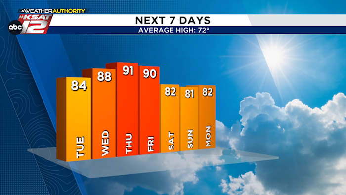
FORECAST HIGHLIGHTS
- MILD TUESDAY: Warmer, near 85°
- WARM THROUGH FRIDAY: Highs near-90°. Warmest possible since late-October
- FIRE DANGER: Windy with gusts up to 35 mph Wednesday through Saturday. Dry weather and winds will increase grassfire danger
FORECAST
After a chilly start today, we begin a warming trend. Temps will be in the mid-80s today, but we’ll likely get into the low-90s Thursday and Friday. That’s the warmest San Antonio has been since late-October.
The warm, sunny weather will mean great pool and splash-pad weather for Spring Breakers. However, winds and dry weather will create a risk for grassfires. Please use caution and practice fire safety!

QUICK WEATHER LINKS
- WATCH LIVE: Doppler Radar
- Hourly and 10-Day Forecast
- Download FREE KSAT Weather Authority App: Up-to-date forecast information and livestreams from trusted local meteorologists.
- KSAT Connect: Share your weather photos.