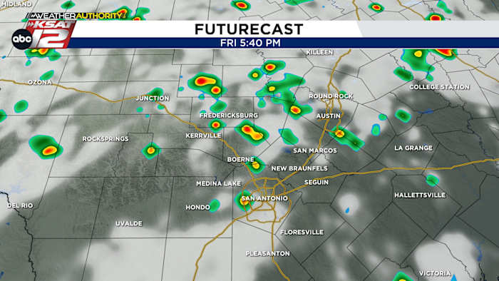
FORECAST HIGHLIGHTS
- RAIN RETURNS: Best odds from 4-8pm today, severe weather NOT expected
- STILL HOT: Despite the rain, we’ll still manage to reach to near 100°
- POP UPS SATURDAY, TOO: Same set up tomorrow
FORECAST
While today could mark our third day in a row to reach 100°, at least some of us will see some cooling showers this afternoon.
AFTERNOON POP-UPS (4-8pm)
It’ll likely take until the evening for clouds to build into downpours. They’ll be spotty and not everyone will get rainfall.
Until then, it’ll be another scorcher of a day, with many of us back near 100°. Humidity levels will also be high. We do NOT expect severe weather or flooding and the activity will die down at sunset.
REPEAT ON SATURDAY
Saturday will shape up to be just like today. Showers and downpours will pop up during the afternoon, starting in the Hill Country and then shifting south toward San Antonio. Temperatures are forecast to be ‘less hot’.

VERY AUGUST-LIKE NEXT WEEK
A generally quiet pattern takes hold next week. We’ll be near 100° each day, with mostly sunny skies. The only thing we’ll need to watch is for a cluster of storms coming out of North Texas Sunday night into Monday. Chances are it’ll stay north of us, but we’ll keep an eye out.

Have a great weekend!
QUICK WEATHER LINKS
- WATCH LIVE: Doppler Radar
- Hourly and 10-Day Forecast
- Download FREE KSAT Weather Authority App: Up-to-date forecast information and livestreams from trusted local meteorologists.
- KSAT Connect: Share your weather photos.