FORECAST HIGHLIGHTS
- RAIN: Tropical moisture and rainmaking energy tonight through tomorrow
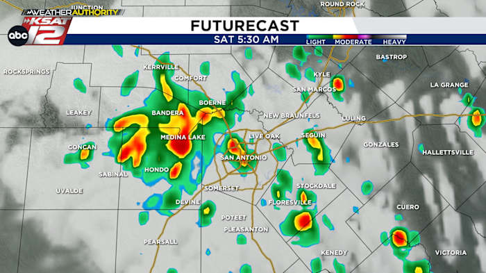
- RAIN: Scattered activity tonight into early Saturday, then more chances later in the day
- FLOODING NOT EXPECTED: Isolated 1″-3″possible, but most will see less than 0.50″
FORECAST
The disturbance in the Gulf has moved onshore, so any chance of tropical development/organization has been eliminated. However, our rain chances spike tonight into tomorrow as the rainmaking energy and tropical moisture moves in.
WHAT DOES IT MEAN FOR US?

- Our best rain chances will be overnight tonight through early Saturday afternoon.
- Most of us will see less than 0.50″, however a lucky few may get a heavier downpour, allowing for 1″+. On the flip side, some of us will see nothing at all. Street flooding, if any at all, would be very isolated.
- It will not bring steady rain, only spotty downpours (50%), so keep your Friday night and Saturday daytime plans. DRY & HOT SUNDAY
Sunny and dry on Sunday with temperatures back to triple digits.
RAIN NEXT WEEK
An active pattern makes a return by the middle of next week. Rain chances look to return, especially by Thursday and Friday. This should help put temperatures a little below 100°.
Stay tuned for updated rain chances as we get closer.

QUICK WEATHER LINKS
- WATCH LIVE: Doppler Radar
- Hourly and 10-Day Forecast
- Download FREE KSAT Weather Authority App: Up-to-date forecast information and livestreams from trusted local meteorologists.
- KSAT Connect: Share your weather photos.