FORECAST HIGHLIGHTS
- THROUGH WEDNESDAY AFTERNOON: Warm and humid
- WEDNESDAY NIGHT: Storms possible, could linger into Thursday morning
- EASTER WEEKEND: Storms likely
-
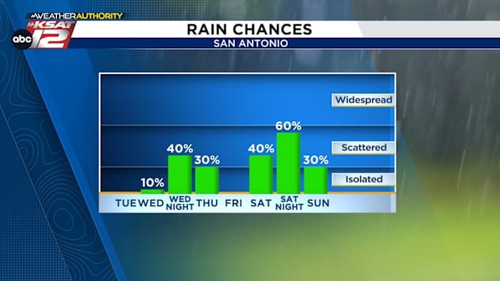
- SATURDAY AFTERNOON: 80s. 40% chance storms
- SATURDAY NIGHT: 60% chance storms
- SUNDAY MORNING: Lingering rain for early church services
- SUNDAY AFTER 11 AM: No rain, much cooler — 60s
FORECAST
TODAY THROUGH WEDNESDAY AFTERNOON
It’ll be warm. By Wednesday afternoon, highs will be near 90°.
WEDNESDAY-THURSDAY
By Wednesday night, an upper level storm system will help to generate a broken line of showers and storms. Any rain is forecast to reach San Antonio late Wednesday night into early Thursday. While widespread severe weather is not expected, a few strong storms are possible. Most folks will get up to 0.10″ to 0.50″, but some lucky neighborhoods will see up to 1″. Skies will clear by midday Thursday, with sunshine returning Thursday afternoon.

EASTER WEEKEND

Saturday is forecast to be warm, ahead of a cold front. As the front arrives Saturday afternoon, showers and storms are possible. Any significant rainfall will push south Saturday night. However, some lingering showers are possible behind the front through early Sunday morning. It’s possible that clouds may linger too, making for a cool, breezy, Easter Sunday. Currently, high temperatures are expected to hold in the 60s.

QUICK WEATHER LINKS
- WATCH LIVE: Doppler Radar
- Hourly and 10-Day Forecast
- Download FREE KSAT Weather Authority App: Up-to-date forecast information and livestreams from trusted local meteorologists.
- KSAT Connect: Share your weather photos.