FORECAST HIGHLIGHTS
- MORNING CLOUDS: They’ll last through 10am
- FRONT FRIDAY: Still on schedule for Friday evening, cooler weekend
- EL NIÑO WATCH: Likely switching to El Nino by Fall
FORECAST
TODAY
These quiet, predictable days are making for a stretch of classic summer-like weather around San Antonio. Sunny afternoons and warm temperatures are sticking around today. We’ll reach the upper-80s this afternoon.

CHANGES FRIDAY/THIS WEEKEND
A cold front will move through Friday evening. There’s no set hour for when the cold front will move in Friday evening, just expect the shift sometime after sunset.
It’ll kick up the winds and drop temperatures over the weekend. Currently, mid-70s are forecast for Saturday. 80s return on Sunday.

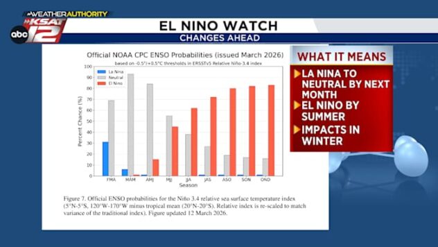
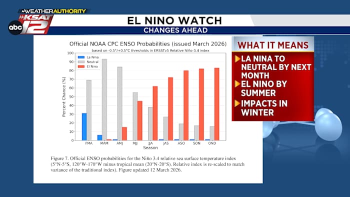
EL NIÑO UPDATE
An El Niño watch has been issued. What does that mean? Not much for now. But it is worth noting that a switch from La Niña to neutral is underway (La Nina has been in place 5 out of the last 6 winters). By the summer, we will make the switch to El Niño. Any affects to the pattern would likely hold off until winter. Could this mean more rain for us? Yes, but it’s not a guarantee. El Niño years typically bring a more active pattern.

QUICK WEATHER LINKS
- WATCH LIVE: Doppler Radar
- Hourly and 10-Day Forecast
- Download FREE KSAT Weather Authority App: Up-to-date forecast information and livestreams from trusted local meteorologists.
- KSAT Connect: Share your weather photos.