FORECAST HIGHLIGHTS
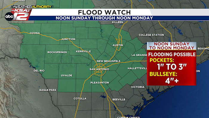
- FLOOD WATCH: Flooding is *possible* Sunday & early Labor Day
- HIGHEST RAIN CHANCE: Sunday afternoon through evening (60%)
- LABOR DAY: Lingering morning storms possible (40%)
- AMOUNTS: Pockets 1″ to 3″, Bullseye 4″+
- CONCERNS: Street flooding, rivers/streams rise
FORECAST
SUNDAY
Storms are starting to develop along a stationary front draped north of the Hill Country. These storms will slowly push south toward the San Antonio metro area through 10 p.m..
Heavy rain with frequent lightning will be slow-moving, quickly producing 1″ to 3″ of rain in pockets, with a 4″+ bullseye of rain possible anywhere in the Flood Watch area. The stronger storms will be capable of 40-50 mph gusts as well.
DON’T CANCEL PLANS
While flooding is possible in spots, it’s important to note that there will still be some folks that miss out on rain entirely. Keep your plans, but have an option ready to duck inside if you happen to get a storm.
STAY AWARE & HAVE A WAY TO GET WEATHER ALERTS
Keep the KSAT Weather Authority handy. We’ll hop on the app and bring you live weather coverage as needed!
REMINDER: A Flood *WATCH* means we’re watching for the possibility of flooding. A Flood *WARNING* means flooding is happening and you should take action. If you get a warning, avoid driving over flooded roads and seek higher ground if necessary.
LABOR DAY

We’ll still need to be on alert for flooding from some lingering morning rain Monday. That being said, there’s less of a rain chance tomorrow. It’ll be cooler, too, with a high near 90°
NEXT WEEK
Quiet, drier, and hotter for most of next week. However, rain returns to the forecast by next weekend

QUICK WEATHER LINKS
- WATCH LIVE: Doppler Radar
- Hourly and 10-Day Forecast
- Download FREE KSAT Weather Authority App: Up-to-date forecast information and livestreams from trusted local meteorologists.
- KSAT Connect: Share your weather photos.