WATCH LIVE RADAR IN VIDEO ABOVE
FORECAST HIGHLIGHTS
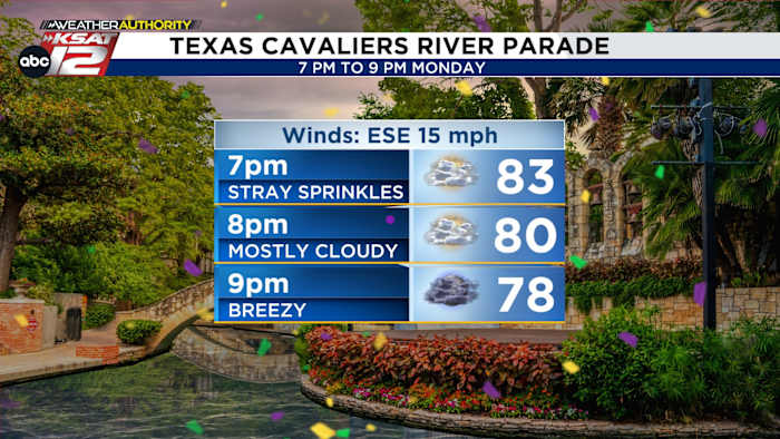
- RIVER PARADE TONIGHT: A few sprinkles possible, but generally windy and mild
- WATCHING OUT WEST: Tonight/Tuesday night, storms west of SA
- RAIN CHANCES INCREASE: Wednesday through Saturday
- IMPACT TO PARADES: Possible, but don’t cancel any plans
FORECAST
We’re entering into what may be busy weather pattern, but that doesn’t mean it’ll rain everyday, all day. In fact, some of us could avoid storms all together. With that said, it’s Fiesta time, so let’s discuss what may lie ahead.
RIVER PARADE TONIGHT, STORMS OUT WEST

The Cavaliers River Parade will perhaps feature some sprinkles at times, but it won’t be consequential. Otherwise, it’ll be breezy, mostly cloudy, and mild.
Tonight & tomorrow night, storms may make a run for areas west of San Antonio during the evening hours. These storms would lose steam before making it to the I-35 corridor. We’ll watch, but impacts should be low from this activity. Otherwise, expect partly to mostly cloudy skies and highs near 90 today and Tuesday.
INCREASING RAIN CHANCE WEDNESDAY

An area of low pressure will arrive Wednesday. This will bring rain chances up, with a few showers and drizzle early in the day, and a chance for a storm or two in the afternoon and evening. While the odds of seeing a storm are low, any storm that develops could become severe.
THURSDAY THROUGH SATURDAY
During this timeframe, we’ll be watching a weak front sliding into the area. It’s along this front that storms may develop. The odds look to be highest Friday into Saturday, but these fronts are notoriously tricky and the timing could change. Obviously, we’ve got two big parades Friday and Saturday, and we’ll be finetuning this forecast as we get closer.

QUICK WEATHER LINKS
- WATCH LIVE: Doppler Radar
- Hourly and 10-Day Forecast
- Download FREE KSAT Weather Authority App: Up-to-date forecast information and livestreams from trusted local meteorologists.
- KSAT Connect: Share your weather photos.