FORECAST HIGHLIGHTS
- TRIPLE DIGIT HEAT: Likely at or above 100° Thu/Fri
- FRONT TIMING: Tricky forecast, but likely moves through sometime on Sunday
- RAIN CHANCES: Small chance Saturday, slightly better odds Sunday
FORECAST
While all eyes are on an early season front, know that the next two days will be scorchers.
TRIPLE DIGITS
If you thought today was hot, Friday’s looking even toastier. Highs are expected to climb just above 100°F, and with humidity in the mix, it could feel more like 105° across the area. It’ll be a scorcher, so make sure you’re staying cool, drinking plenty of water, and limiting time outside during peak afternoon hours.
EARLY SEASON FRONT UPDATE
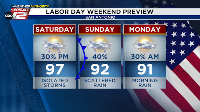
Trying to nail down the exact timing of an early season front is always tough. They can stall and their movements are often driven by thunderstorm activity. With that in mind, expect the front to stall at our doorstep Saturday afternoon. This should help kick off some isolated storms, mainly along and north of I-10. Gusty winds and brief, heavy rain would be possible late in the day. Saturday will still be hot, with highs in the mid to upper-90s.

The front should get a push through overnight into Sunday, allowing it to move through San Antonio. Don’t expect a dramatic cool-down. It will, however, help to stir up a few more showers and storms on Thursday. Rain chances sit at 40%. Temps likely still make the low-90s.
The bigger question is how far south the front will move by Monday. As of now, we believe that it’ll be far enough south to take much of the rain chances with it. That said, some lingering rain is possible early on Labor Day.
DRIER NEXT WEEK
By Tuesday and Wednesday, drier conditions take over and temperatures return to the mid-90s.

QUICK WEATHER LINKS
- WATCH LIVE: Doppler Radar
- Hourly and 10-Day Forecast
- Download FREE KSAT Weather Authority App: Up-to-date forecast information and livestreams from trusted local meteorologists.
- KSAT Connect: Share your weather photos.