WATCH LIVE RADAR ABOVE
FORECAST HIGHLIGHTS
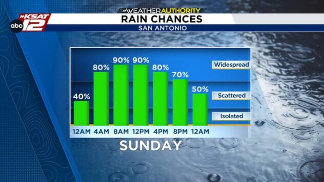
- MONDAY Continued rounds of rain continuing
- RAINFALL TOTALS: Most areas receive 1 to 3 inches through Monday night.
-
- IMPACTS: Ponding on roads and localized street flooding.
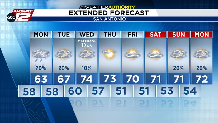
- NEXT WEEK: The sun returns with temps climbing back into the 70s.
FORECAST
RAINFALL TOTALS
Several locations in Edwards, Real, and Bandera counties have already picked up 3 to 5 inches of rain, prompting Flash Flood Warning for portions of the Hill Country and reports of flooded low-water crossings. For San Antonio, totals were a lighter with some getting over an inch!


COOL, WET, DREARY THROUGH MONDAY
Expect a damp, gloomy stretch of weather to continue through Monday. Rain will not fall continuously at every location, but periods of rain and occasional heavier showers can be expected through Monday evening. Temperatures will remain well below average, with highs mostly in the upper 50s to lower 60s under thick cloud cover.

NEXT WEEK
The storm system exits Tuesday with lingering showers east of I-35. Drier air arrives Wednesday as a cold front brings sunshine and highs in the 70s. Expect cooler mornings late in the week, with temperatures potentially dropping into the 40s.

QUICK WEATHER LINKS
- WATCH LIVE: Doppler Radar
- Hourly and 10-Day Forecast
- Download FREE KSAT Weather Authority App: Up-to-date forecast information and livestreams from trusted local meteorologists.
- KSAT Connect: Share your weather photos.