FORECAST HIGHLIGHTS
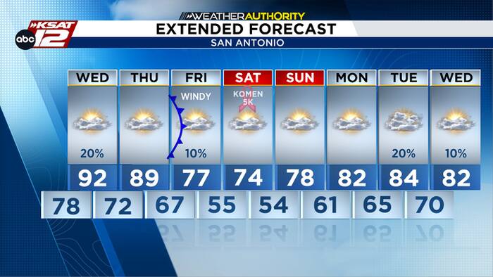
- HOT & HUMID: SA hit 92° today … similar Wednesday
- STRAY SHOWER WEDNESDAY: Odds sit at 20%
- COLD FRONT: Arrives pre-dawn Friday, with significant temp change, windy
FORECAST
HOT & HUMID AGAIN TOMORROW
After a cloudy morning in the upper 70s, afternoon sun will help to push temperatures into the low 90s again Wednesday afternoon. That’s not quite a record, but it is well-above average. A high near 92° will translate to a heat index in the mid/upper 90s.
STRAY SHOWER POSSIBLE
A stray shower is possible tomorrow, but don’t get your hopes up because it’s just a 20% chance. Most of us will stay dry.
COLD FRONT EARLY FRIDAY
A cold front is scheduled to blow through pre-dawn Friday. That means we’ll go from highs near 90° on Thursday, to gusty winds and temps in the mid-60s Friday morning. Mid-70s are expected Friday afternoon. Saturday morning will see temps drop into the 50s in San Antonio! Be prepared for wind gusts up to 35-40 mph Friday morning through Saturday morning, so secure any outdoor Halloween decorations by Friday morning!
QUICK WEATHER LINKS
- WATCH LIVE: Doppler Radar
- Hourly and 10-Day Forecast
- Download FREE KSAT Weather Authority App: Up-to-date forecast information and livestreams from trusted local meteorologists.
- KSAT Connect: Share your weather photos.