FORECAST HIGHLIGHTS
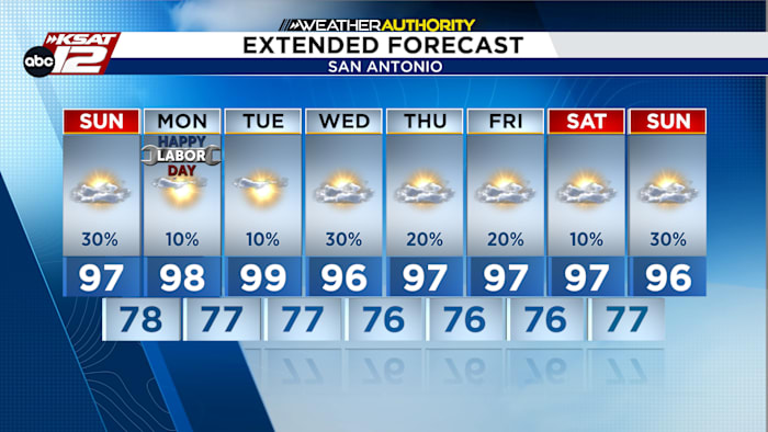
- SUNDAY: Hot and humid; 30% chance of showers & storms
- LABOR DAY: Labor Day remains hot and humid, with highs near 100°.
- NEXT WEEK: Hot and humid with heat indices approaching 108°
- MORE RAIN CHANCES: Daily showers and thunderstorms
FORECAST
SUNDAY
A hot and humid Sunday is ahead, with temperatures climbing into the upper 90s to near 100°. A few isolated to scattered showers and thunderstorms could develop during the afternoon and early evening as a weak disturbance moves inland from the Gulf. Most storms will fade after sunset, but stronger storms could produce gusty winds.

LABOR DAY
Monday will remain hot, humid and unsettled. Temperatures will again reach the upper 90s to near 100°, with afternoon thunderstorms possible. Heat index values will remain close to heat-advisory levels, so continue to take precautions if spending time outdoors.

MORE RAIN CHANCES
The heat and humidity will continue through much of next week as a strong ridge of high pressure remains in control across South-Central Texas. Daily sea-breeze thunderstorms are possible along the Coastal Plains, particularly Tuesday through Thursday, but rain chances will remain relatively low for most locations. Otherwise, expect mostly hot and dry conditions with temperatures near 100° and warm, muggy nights.

QUICK WEATHER LINKS
- WATCH LIVE: Doppler Radar
- Hourly and 10-Day Forecast
- Download FREE KSAT Weather Authority App: Up-to-date forecast information and livestreams from trusted local meteorologists.
- KSAT Connect: Share your weather photos.