FORECAST HIGHLIGHTS
- RAINFALL TOTALS: Friday’s storms left plenty of damage and over 2″ of rain
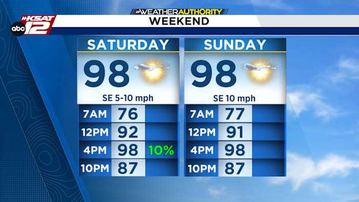
- THIS WEEKEND: Mostly sunny and hot, highs in the upper 90s.
- EARLY WEEK: Isolated Seabreeze showers possible near the Coastal Plains; otherwise dry.
- FEELING LIKE SUMMER: Continued hot weather with highs in the 90s and only slight rain chances.
FORECAST
RAINFALL TOTALS FROM FRIDAY
The stormy pattern that brought gusty winds and beneficial rain over the past couple of days has come to an end for San Antonio. But not before leaving plenty of damage and heavy rain leading to flooding in some areas. Here is a took at the latest rainfall totals.

THIS WEEKEND
Rain chances are essentially finished for San Antonio through the weekend, with dry conditions expected area-wide. Expect plenty of sunshine and hot afternoon temperatures both Saturday and Sunday. Highs will climb into the upper 90s across much of the area, with some locations approaching the 100-degree mark.

While temperatures will be hot, the good news is that most communities should remain just shy of the triple-digit heat that has dominated much of the summer.
EXTENDED FORECAST
The extended forecast offers a welcome change from recent weeks, with temperatures expected to stay below 100 degrees for much of the upcoming week. Isolated showers and thunderstorms, driven by the afternoon Seabreeze, may develop along the Coastal Plains A few isolated showers may develop at times, especially closer to the coast, but most of South Central Texas can expect a stretch of hot and mainly dry weather.

QUICK WEATHER LINKS
- WATCH LIVE: Doppler Radar
- Hourly and 10-Day Forecast
- Download FREE KSAT Weather Authority App: Up-to-date forecast information and livestreams from trusted local meteorologists.
- KSAT Connect: Share your weather photos.