FORECAST HIGHLIGHTS
- MONDAY: Hot afternoon with temps feeling like 100+°, a 30% chance stray shower
- NEXT WEEK: No rain & hot!
- TROPICS: Eyes on potential development NEXT weekend
FORECAST
Hope you’ve been enjoying your weekend! It has definitely felt like summer out there and that weather pattern will continue in the week ahead.
MONDAY
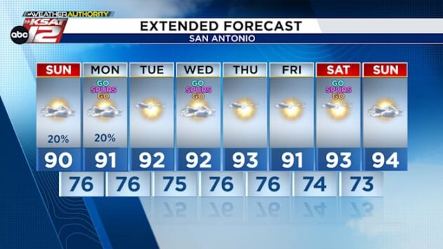
Your Monday will start with muggy conditions and temperatures in the upper 70s. Skies will remain partly cloudy through the day. Showers with potentially a rumble of thunder or two will develop in the early afternoon over areas southeast of San Antonio. That shower activity will be very spotty in nature and move northwest through the later afternoon hours. Once the sun has set, shower activity will fall apart and the rest of your Spurs watch party weather will remain dry.

NEXT WEEK
High pressure and Gulf moisture will keep our pattern steady this week. Highs gradually climb into the mid to upper 90s, with heat index values in the triple digits each afternoon thanks to the humidity.
After Monday’s showers, rain chances will drop off during the week ahead. A change in our weather pattern could dissolve this week’s high pressure and potentially bring more tropical moisture at the start of next week.

QUICK WEATHER LINKS
- WATCH LIVE: Doppler Radar
- Hourly and 10-Day Forecast
- Download FREE KSAT Weather Authority App: Up-to-date forecast information and livestreams from trusted local meteorologists.
- KSAT Connect: Share your weather photos.