WATCH LIVE RADAR IN VIDEO PLAYER ABOVE
FORECAST HIGHLIGHTS
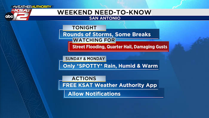
- SATURDAY: We could redevelop storms later tonight. If a storm pops up, keep this in mind:
-
- RISKS: Street flooding, quarter sized hail, damaging gusts
- ACTIONS: Keep KSAT Weather Authority App handy & allow notifications, especially if you have outdoor plans Saturday
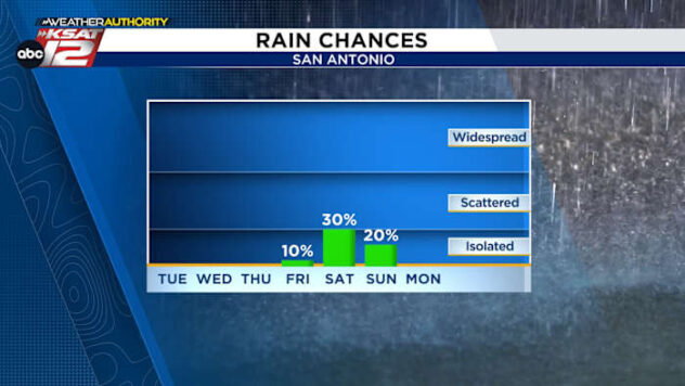
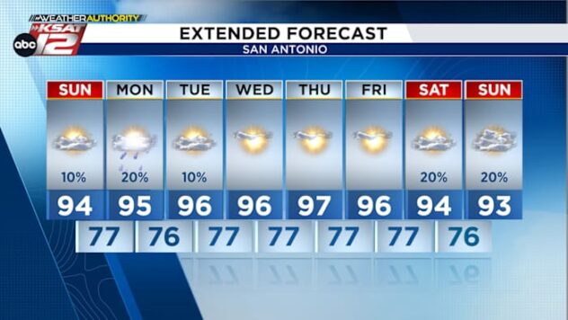
- QUIETER SUNDAY & MONDAY: More sun, less storm activity. Chance is only 20% to 30%. Humid & warm.
- NEXT WEEK: Rain returns Tuesday afternoon through Wednesday morning
FORECAST
REST OF YOUR SATURDAY
Our first round of storms left San Antonio early after noon with some spot seeing 1″-3″!

Some storms could redevelop late this afternoon and evening. Wherever rain pops up, street flooding and strong storms will be possible. These storms could produce up to quarter sized hail and damaging wind gusts. The primary concern, however, is the risk for heavy downpours.

A Flood Watch has been issued for most of the area. It’s in effect tonight through Monday, however, our main concern is for street flooding will be today. Your best bet is to stay weather aware all day, keeping the KSAT Weather Authority app and radar handy.
SUNDAY & MONDAY
For those with outdoor plans this Memorial Day weekend, we do expect quieter conditions on Sunday and Monday. Isolated activity will remain possible, but will be driven by afternoon heating. Rain chances Sunday sit at 30%, while lower odds are expected on Memorial Day.

NEXT WEEK
After a break from widespread rain Sunday & Monday, another low pressure system will move across South Central Texas. This increases storm chances again Tuesday afternoon through Wednesday morning. Then, expect a drier and warmer weather pattern to end the week.

QUICK WEATHER LINKS
- WATCH LIVE: Doppler Radar
- Hourly and 10-Day Forecast
- Download FREE KSAT Weather Authority App: Up-to-date forecast information and livestreams from trusted local meteorologists.
- KSAT Connect: Share your weather photos.