FORECAST HIGHLIGHTS
- TONIGHT: A few storms weaken as they approach SA from the west
- WATCHING TONIGHT: Small chance for overnight storms
- RAIN SATURDAY/FLOOD WATCH IN EFFECT: Locally heavy rainfall at times but NOT continuously throughout the day
- QUIETER SUNDAY & MONDAY: More sun, less storm activity
FORECAST
TONIGHT
A few storms in Mexico and West Texas should weaken as they move toward San Antonio around 10pm-11pm tonight, but we’re watching for the off chance of them organizing.
- SPURS WATCH PARTIES: Those headed to outdoor watch parties tonight should keep an eye on the radar. We’ll keep you updated should any isolated storms pop-up
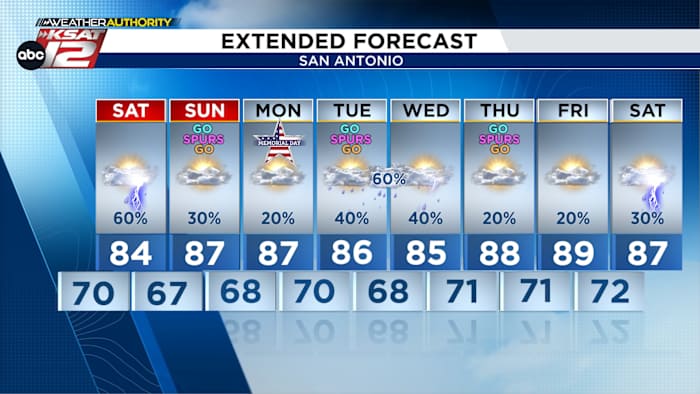
⚠ HEAVY RAIN POSSIBLE SATURDAY ⚠
An upper low will swing through on Saturday, enhancing rain chances. In this type of messy pattern, storms could pop up just about anywhere, anytime, so pinpointing where the heaviest rain may fall is a difficult task. Also, this will not be a continuous rainfall at any given location. There will be breaks and periods of sunshine.

A Flood Watch has been issued for most of the area. It’s in effect tonight through Monday, however, our main concern is for street flooding will Saturday afternoon. Again, it will not be raining all day as this is a more scattered, pop-up type scenario.

SUNDAY & MONDAY
For those with outdoor plans this Memorial Day weekend, we do expect quieter conditions on Sunday and Monday. Isolated activity will remain possible, but will be driven by afternoon heating. Rain chances Sunday sit at 30%, while lower odds are expected on Memorial Day.

QUICK WEATHER LINKS
- WATCH LIVE: Doppler Radar
- Hourly and 10-Day Forecast
- Download FREE KSAT Weather Authority App: Up-to-date forecast information and livestreams from trusted local meteorologists.
- KSAT Connect: Share your weather photos.