FORECAST HIGHLIGHTS
- MORE STORMS OVERNIGHT: Another round of storms likely tonight, early Thursday
-
- RISK: Primarily street flooding
- INCONVENIENCE: Thunder may wake you/children/pets overnight
- ACTION: Check weather before morning commute
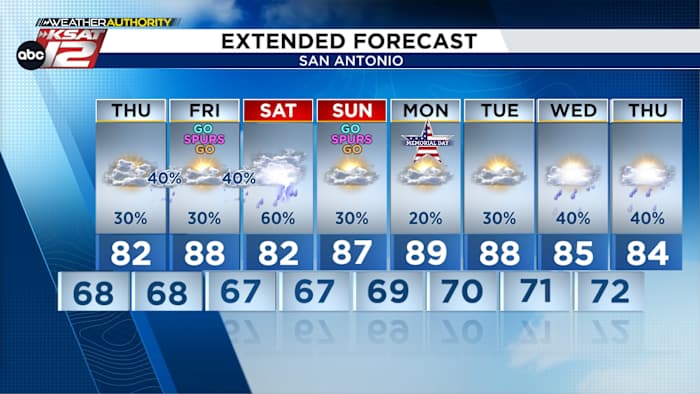
- MEMORIAL DAY WEEKEND: Storms Saturday, quieter by Sunday & Monday
FORECAST
Loud storms last night produced healthy rainfall (0.75-2″) around the area, but we’re not done with rain yet. Plan for more rounds of storms through the next ten days.
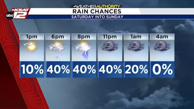
OVERNIGHT

The first storms are likely to develop near the Rio Grande tonight, then move east and make it to San Antonio around 3am or so. The primary risk around San Antonio is street flooding for the morning commute, but closer to the Rio Grande, there’s a chance for localized hail and high winds.

MEMORIAL DAY WEEKEND
After a quiet Friday, another round of storms are possible into Saturday with street flooding the main concern. It won’t rain all day, but there’s likely to be a period of time or two throughout the day with scattered storms.

Not all hope is lost for outdoor activities. Sunday looks to be drier and sunnier, along with Memorial Day. While isolated storms can’t be ruled out, the odds of widespread rainfall will be lower.
NEXT WEEK
Our weather pattern stays active with more scattered storms likely at times.
QUICK WEATHER LINKS
- WATCH LIVE: Doppler Radar
- Hourly and 10-Day Forecast
- Download FREE KSAT Weather Authority App: Up-to-date forecast information and livestreams from trusted local meteorologists.
- KSAT Connect: Share your weather photos.