FORECAST HIGHLIGHTS
- ISOLATED RAIN TODAY: Stray shower, storm possible this afternoon
- COLD FRONT SATURDAY 4PM: Broken line of showers & storms upon arrival
- DAMP, COOL EASTER SUNDAY: Cloudy with rain; highs in the 50s & 60s
FORECAST
TODAY
Ahead of an approaching storm system, isolated showers and storms are possible this afternoon. However, rain will not be widespread with only peeks of afternoon sun. High temperatures will reach the upper-80s, making today the warmest day of the weekend.
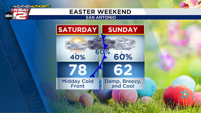
SATURDAY
The morning will be mostly cloudy with temperatures in the 70s and about a 40% chance for scattered showers or a stray thunderstorm. By midday and into the early afternoon, showers and storms will become more widespread as the front gets closer. The front is expected to reach San Antonio around 4 PM, bringing a broken line of showers and thunderstorms along the boundary and raising rain chances to around 60%.

Winds pick up and temperatures begin to fall behind the front. During the evening and overnight hours, a few spotty leftover showers are possible, with cloudy skies, gusty winds, and steadily cooling temperatures dropping into the 50s by late evening.

EASTER SUNDAY
Cooler air settles in behind the front, keeping Easter Sunday damp and chilly. The morning will be cloudy and cool, with showers likely and temperatures holding in the 50s. Periods of rain continue through midday and the early afternoon, and highs will struggle to reach the low 60s.

By Sunday evening, rain gradually tapers off, but skies remain mostly cloudy and temperatures stay cool, making it a good night for cozy indoor plans.
MONDAY & BEYOND
Small rain chances remain in the forecast Monday and Tuesday, before quieter conditions take over midweek.

QUICK WEATHER LINKS
- WATCH LIVE: Doppler Radar
- Hourly and 10-Day Forecast
- Download FREE KSAT Weather Authority App: Up-to-date forecast information and livestreams from trusted local meteorologists.
- KSAT Connect: Share your weather photos.